Santa Clarita, California
| Santa Clarita, California | |||
|---|---|---|---|
| City | |||
| City of Santa Clarita | |||

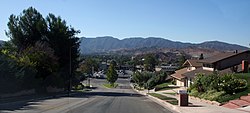
Santa Clarita's Canyon Country in September 2008.
|
|||
|
|||
 Location of Santa Clarita in California and Los Angeles County |
|||
| Location in the United States | |||
| Coordinates: 34°25′00″N 118°30′23″W / 34.41667°N 118.50639°W | |||
| Country | |||
| State |
|
||
| County |
|
||
| Incorporated | December 15, 1987 | ||
| Government | |||
| • Type | Council-Manager | ||
| • Mayor | Cameron Smyth | ||
| • Mayor Pro-Tem | Laurene Weste | ||
| • City council | Bob Kellar Marsha McLean Bill Miranda |
||
| • City manager | Ken Striplin | ||
| Area | |||
| • City | 64.4 sq mi (166.79 km2) | ||
| • Land | 64.34 sq mi (166.64 km2) | ||
| • Water | 0.06 sq mi (0.155 km2) 0.099% | ||
| Elevation | 1,207 ft (368 m) | ||
| Population (January 1, 2016) | |||
| • City | 219,611 | ||
| • Rank |
3rd in Los Angeles County 24th in California |
||
| • Density | 3,400/sq mi (1,300/km2) | ||
| • Metro | 13,155,788 | ||
| Demonym(s) | Santa Claritan | ||
| Time zone | Pacific (UTC−08:00) | ||
| • Summer (DST) | PDT (UTC−07:00) | ||
| ZIP codes | 91310, 91321–91322, 91350–91351, 91354–91355, 91380–91387, 91390 | ||
| Area code | 661 | ||
| FIPS code | 06-69088 | ||
| GNIS feature IDs | 1662338, 2411819 | ||
| Website | www |
||
Santa Clarita, officially the City of Santa Clarita, is the third largest city in Los Angeles County, California, and the seventeenth largest in the state of California. The city has annexed a number of unincorporated areas, contributing to the large population increase. It is located about 35 miles (56 km) northwest of downtown Los Angeles, and occupies most of the Santa Clarita Valley. It is a notable example of a U.S. edge city or boomburb. Santa Clarita was ranked by Money magazine in 2006 as 18th of the top 100 places to live.
Santa Clarita was incorporated in December 1987 as the union of four unincorporated communities, Canyon Country, Newhall, Saugus, and Valencia, all of which are situated on the land of the former Rancho San Francisco. The four communities retain separate identities, and it is common for residents to refer to a specific neighborhood when asked where they are from. Santa Clarita is bounded on the west by the Golden State Freeway (I-5). The Antelope Valley Freeway (SR-14) runs northeast-southwest through an irregular east border, and the Newhall Pass is the city's southernmost point.
Santa Clarita is often associated with the Six Flags Magic Mountain amusement park, though the park is located just outside the city limits, and the California Institute of the Arts (CalArts), located in Valencia.
Santa Clarita was incorporated in December 1987, but its history stretches back several centuries. About AD 450, the Tataviam arrived, numbering around 2,000 at their zenith.
...
Wikipedia


