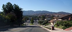
Canyon Country, Santa Clarita, California
| Canyon Country | |
|---|---|
| City | |

A neighborhood in the Sierra Pelona Mountains, in Canyon Country near the central Sand Canyon and Soledad Canyon Roads junction with the San Gabriel Mountains in the background.
|
|
| Position in Los Angeles County. | |
| Coordinates: 34°25′24″N 118°28′17″W / 34.42333°N 118.47139°WCoordinates: 34°25′24″N 118°28′17″W / 34.42333°N 118.47139°W | |
| Country |
|
| State |
|
| County | Los Angeles |
| City | Santa Clarita |
| Elevation | 466 m (1,529 ft) |
| Population (2010) | |
| • Total | 59,530 |
| Time zone | Pacific (PST) (UTC-8) |
| • Summer (DST) | PDT (UTC-7) |
| ZIP Code | 91351 |
| Area code(s) | 661 |
| GNIS feature ID | 2583151 |
| Website | http://www.santa-clarita.com/ |
| U.S. Geological Survey Geographic Names Information System: Canyon Country, Santa Clarita, California | |
Canyon Country is a community and district within the city of Santa Clarita, located in northwestern Los Angeles County, California, United States.
Canyon Country is north of the San Fernando Valley via Newhall Pass through the Santa Susana and San Gabriel Mountains. Canyon Country is located in the upper watershed of the Santa Clara River in the Santa Clarita Valley and Sierra Pelona Mountains foothills.
The area was the ancestral homeland of the Tataviam people for over five hundred years, and other tribes before then, such as the Tongva, Kitanemuk, and Serrano people. After the Spanish invasion, the valley first became grazing lands of the Mission San Fernando Rey de España around 1790. In 1834, after Mexican Independence, it became part of the Rancho San Francisco land grant centered on the confluence of the Santa Clara River and Castaic Creek.
In the 1880s the rancho become the Newhall Ranch empire of Henry Newhall, now the present day Newhall Land and Farming Company. In 1928 the St. Francis Dam collapsed, suddenly flooding and washing away settlements and people along the Santa Clara River section of present-day Santa Clarita not including Canyon Country. Canyon Country was originally to be called Solemint. It later absorbed the community to the west called Honby. In the 1960s and 1970s the Newhall Land company's suburban developments transformed Canyon Country and the surrounding towns into a focused residential and cultural city.
...
Wikipedia

