River Otter, Devon
|
River Otter |
|
|
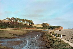
The tidal estuary of the Otter. The river flows left to right, in front of the distinctive hill. The marsh (foreground) is separated from the sea by a steep pebble bar (right).
|
|
| Country | England |
|---|---|
| Counties | Somerset, Devon |
| Source | |
| - location | Blackdown Hills, Somerset, England |
| - elevation | 278 m (912 ft) |
| Mouth | |
| - location | Budleigh Salterton, Devon, England |
| - elevation | 0 m (0 ft) |
| Length | 32 km (20 mi) |
| Discharge | for Dotton |
| - average | 3.12 m3/s (110 cu ft/s) |
| - max | 346.7 m3/s (12,244 cu ft/s) (11 July 1968) |
| - min | 0.46 m3/s (16 cu ft/s) (24 August 1976) |
| Discharge elsewhere (average) | |
| - Fenny Bridges | 2.13 m3/s (75 cu ft/s) |
|
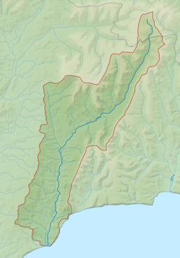
Map of the River Otter and its catchment.
|
|
The River Otter rises in the Blackdown Hills just inside the county of Somerset, England near Otterford, then flows south for some 32 km through East Devon to the English Channel at the western end of Lyme Bay, part of the Jurassic Coast, a UNESCO World Heritage Site. The Permian and Triassic sandstone aquifer in the Otter Valley is one of Devon's largest groundwater sources, supplying drinking water to 200,000 people.
The river's source is north of Otterford, where a stream feeds the Otterhead Lakes: ST225152 and then through Churchstanton before entering Devon.
The river flows through a predominantly rural area, with small cattle, sheep and dairy farms. The largest town in the Otter Valley is Honiton. Tourism and leisure play important roles in the economy; hundreds of private cottages and farms offer B&B and rented holiday accommodation. For much of its length, the river flows through one or other Area of Outstanding Natural Beauty – The Blackdown Hills AONB (to the north of Honiton) and East Devon AONB (to the south of Ottery St Mary).
The river passes through or by Upottery, Rawridge, Monkton, Honiton (then below the A30 trunk road), Alfington, Ottery St Mary, Tipton St John, Newton Poppleford, Otterton and reaches the coast to the east of Budleigh Salterton, after flowing through the 57-acre (230,000 m2) Otter Estuary Nature Reserve – a Site of Special Scientific Interest (SSSI) – consisting of tidal mudflats and saltmarsh. There is no public access to the estuary itself but footpaths lead alongside with two viewing platforms on the west and two hides one on the west and one on the east. The wintering population of wildfowl and waders includes redshank, greenshank, dunlin, common sandpiper, ringed plover, grey plover, curlew, snipe, water rail, wigeon, teal, shelduck, brent goose, red-breasted merganser and little grebe. Reed warbler, reed bunting and sedge warbler breed on the reserve.
...
Wikipedia


