Maumee, Ohio
| Maumee, Ohio | |
|---|---|
| City | |
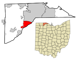
 Location in Lucas County and the state of Ohio. |
|
| Coordinates: 41°34′14″N 83°39′9″W / 41.57056°N 83.65250°WCoordinates: 41°34′14″N 83°39′9″W / 41.57056°N 83.65250°W | |
| Country | United States |
| State | Ohio |
| County | Lucas |
| Government | |
| • Mayor | Richard H. Carr (R) |
| Area | |
| • Total | 10.61 sq mi (27.48 km2) |
| • Land | 9.89 sq mi (25.61 km2) |
| • Water | 0.72 sq mi (1.86 km2) |
| Elevation | 633 ft (193 m) |
| Population (2010) | |
| • Total | 14,286 |
| • Estimate (2015) | 13,940 |
| • Density | 1,444.5/sq mi (557.7/km2) |
| Time zone | EST (UTC−5) |
| • Summer (DST) | EDT (UTC−4) |
| ZIP code | 43537 |
| Area code(s) | 419/567 |
| FIPS code | 39-48342 |
| GNIS feature ID | 1061485 |
| Website | www.maumee.org |
Maumee (maw-MEE) is a city in Lucas County, Ohio, United States. Located along the Maumee River, it is a suburb about 10 miles southwest of Toledo. The population was 14,286 at the 2010 census. Maumee was declared an All-America City by the National Civic League in June 2006.
Maumee is located at 41°34′14″N 83°39′9″W / 41.57056°N 83.65250°W (41.570545, -83.652503). It is about 11 miles upriver of Toledo, which is at the mouth of the Maumee River on Maumee Bay. This is a roughly triangle-shaped city. Its borders are formed by Interstate 80/90 to the north, to the west by Interstate 475/U.S. Route 23, and to the southeast by the Maumee River. It is just downriver from Waterville.
According to the United States Census Bureau, the city has a total area of 10.61 square miles (27.48 km2), of which 9.89 square miles (25.61 km2) is land and 0.72 square miles (1.86 km2) is water.
...
Wikipedia
