Lake Turkana
| Lake Turkana Jade Sea |
|
|---|---|
 |
|
 |
|
| Coordinates | 3°35′N 36°7′E / 3.583°N 36.117°ECoordinates: 3°35′N 36°7′E / 3.583°N 36.117°E |
| Lake type | Saline, monomictic, alkaline, endorheic |
| Primary inflows | Omo River, Turkwel River, Kerio River |
| Primary outflows | Evaporation |
| Catchment area | 130,860 km2 (50,530 sq mi) |
| Basin countries | Kenya, Ethiopia |
| Max. length | 290 km (180 mi) |
| Max. width | 32 km (20 mi) |
| Surface area | 6,405 km2 (2,473 sq mi) |
| Average depth | 30.2 m (99 ft) |
| Max. depth | 109 m (358 ft) |
| Water volume | 203.6 km3 (165,100,000 acre·ft) |
| Salinity | 2.44% |
| Surface elevation | 360.4 m (1,182 ft) |
| Islands | North Island, Central Island, South Island (volcanic) |
| Settlements | El Molo, Loyangalani, Kalokol, Eliye Springs, Ileret, Fort Banya. |
| Lake Turkana National Parks | |
|---|---|
| Name as inscribed on the World Heritage List | |
 |
|
| Location | Kenya |
| Type | Natural |
| Criteria | viii, x |
| Reference | 801 |
| UNESCO region | Africa |
| Inscription history | |
| Inscription | 1997 (21st Session) |
| Extensions | 2001 |
|
IUCN category II (national park)
|
|
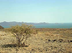
Lake Turkana (/tɜːrˈkɑːnə/ or /tɜːrˈkænə/), formerly known as Lake Rudolf, is a lake in the Kenyan Rift Valley, in northern Kenya, with its far northern end crossing into Ethiopia. It is the world's largest permanent desert lake and the world's largest alkaline lake. By volume it is the world's fourth-largest salt lake after the Caspian Sea, Issyk-Kul, and Lake Van (passing the shrinking South Aral Sea), and among all lakes it ranks 24th. The water is potable, but not palatable. It supports a rich lacustrine wildlife. The climate is hot and very dry.
The rocks of the surrounding area are predominantly volcanic. Central Island is an active volcano, emitting vapour. Outcrops and rocky shores are found on the east and south shores of the lake, while dunes, spits and flats are on the west and north, at a lower elevation.
On-shore and off-shore winds can be extremely strong, as the lake warms and cools more slowly than the land. Sudden, violent storms are frequent. Three rivers (the Omo, Turkwel and Kerio) flow into the lake, but lacking outflow, its only water loss is by evaporation. Lake volume and dimensions are variable. For example, its level fell by 10 metres between 1975 and 1993.
...
Wikipedia
