Fremantle, Western Australia
|
Fremantle Perth, Western Australia |
|
|---|---|

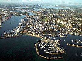
Aerial view of Fremantle
|
|
| Coordinates | 32°03′25″S 115°44′38″E / 32.05694°S 115.74389°ECoordinates: 32°03′25″S 115°44′38″E / 32.05694°S 115.74389°E |
| Population | 26,582 (2011 census) |
| • Density | 1,399/km2 (3,624/sq mi) |
| Established | 1829 |
| Postcode(s) | 6160 |
| Area | 19.0 km2 (7.3 sq mi) |
| Time zone | AWST (UTC+8) |
| Location | 19 km (12 mi) SW of Perth CBD |
| LGA(s) | City of Fremantle |
| State electorate(s) | Fremantle |
| Federal Division(s) | Fremantle |
| Australian Convict Sites | |
|---|---|
| Name as inscribed on the World Heritage List | |

Fremantle Prison, one of eleven World Heritage-listed Australian Convict Sites
|
|
| Location | Australia |
| Type | Cultural |
| Criteria | iv, vi |
| Reference | 1306 |
| UNESCO region | Asia-Pacific |
| Inscription history | |
| Inscription | 2010 (34th Session) |
Fremantle (/ˈfriːmæntəl/) is a major Australian port city in Western Australia, located at the mouth of the Swan River. Fremantle Harbour serves as the port of Perth, the state capital. Fremantle was the first area settled by the Swan River colonists in 1829. It was declared a city in 1929, and has a population of approximately 27,000.
The city is named after Captain Charles Fremantle, the English naval officer who established a camp at the site on 2 May 1829. The city contains well-preserved 19th century buildings and other heritage features. The Western Australian vernacular diminutive for Fremantle is Freo. The Nyungar name for the area is Walyallup.
Fremantle lies on a series of limestone hills known by the Nyungar people as Booyeembara; the sandplain to the east is Gardoo. The original vegetation of the area was mainly Xanthorrhoea and eucalyptus trees, which were traditionally fired annually by the Aboriginal people.
The suburb of Fremantle is bounded by the Swan River to the north and north-west, the Indian Ocean to the west, South Street to the south, and the suburbs of East Fremantle and White Gum Valley to the east. The central part of the suburb extends eastwards to include Royal Fremantle Golf Club and a suburban area south of Marmion Street and west of Carrington Street. The City of Fremantle local government area also includes the suburbs of Beaconsfield, Hilton, North Fremantle, O'Connor, Samson, South Fremantle, and White Gum Valley. East Fremantle has its own town council and is not governed by the City of Fremantle.
...
Wikipedia

