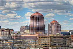
Downtown Albuquerque
| Downtown | |
|---|---|
| Neighborhood of Albuquerque | |

Downtown Albuquerque
|
|
| Coordinates: 35°05′02″N 106°39′00″W / 35.084°N 106.65°WCoordinates: 35°05′02″N 106°39′00″W / 35.084°N 106.65°W | |
| Government | |
| • City Council | Debbie O'Malley |
| • State House | Rick Miera (D) |
| • State Senate | Jerry Ortiz y Pino (D) |
| • U.S. House | Michelle Lujan Grisham (D) |
| Area | |
| • Total | 0.40 sq mi (1.0 km2) |
| Population (2010) | |
| • Total | 1,237 |
| • Density | 3,092.5/sq mi (1,194.0/km2) |
| ZIP Code | 87102 |
| Area code(s) | 505 |
Downtown Albuquerque is the central business district of Albuquerque, New Mexico. It is where a large number of the city's highrise buildings are located, as well as being the center of government and business for the region.
Downtown is roughly defined as the area between Marble Avenue, Coal Avenue, Sixth Street, and the Burlington Northern Santa Fe railroad tracks. The area on the east side of the railroad tracks is known as East Downtown or EDo.
Downtown Albuquerque is laid out in a standard grid pattern, with numbered north-south streets and named east-west avenues. Central Avenue (originally known as Railroad Avenue) is the main east-west thoroughfare through the center of Downtown, while Lomas Boulevard (originally New York Avenue) is a major east-west arterial through the north part of downtown.
The streets start with First Street just west of the railroad tracks and increase in number moving westward. Fourth Street was originally the main north-south thoroughfare through Downtown but today it is discontinuous, interrupted by Civic Plaza and a two-block pedestrian mall north of Central. Since these developments took place Second Street has been the main north-south street through downtown.
Fourth Street through downtown Albuquerque was part of U.S. Route 66 prior to the route's 1937 realignment. Afterwards, Route 66 ran along Central Avenue until its decommissioning.
Downtown Albuquerque is divided into six official districts, which are identified by a unified system of signage and icons.
Located on the north side of downtown, this district is bounded by Marble Avenue, Roma Avenue, Second Street, and Seventh Street. It is named for the three major courthouses located at the intersection of Fourth and Lomas: Pete V. Domenici United States Courthouse, Bernalillo County Courthouse, and the Bernalillo County Metropolitan Courthouse.
On the north side of downtown along the railroad tracks, the Warehouse District includes the area between Second and the railroad tracks, north of the Convention Center to Slate Avenue. As its name implies, this area contains mostly warehouses from the railroad era.
...
Wikipedia
