Zumarraga, Samar
| Zumarraga | |
|---|---|
| Municipality | |
| Municipality of Zumarraga | |

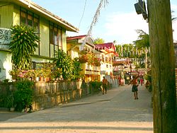
Downtown area
|
|
 Map of Samar with Zumarraga highlighted |
|
| Location within the Philippines | |
| Coordinates: 11°38′N 124°51′E / 11.63°N 124.85°ECoordinates: 11°38′N 124°51′E / 11.63°N 124.85°E | |
| Country |
|
| Region | Eastern Visayas (Region VIII) |
| Province | Samar |
| District | 2nd district of Samar |
| Barangays | 25 (see Barangays) |
| Government | |
| • Type | Sangguniang Bayan |
| • Mayor | Neliptha “Nelip” Figueroa |
| • Electorate | 11,415 voters (2016) |
| Area | |
| • Total | 38.55 km2 (14.88 sq mi) |
| Population (2015 census) | |
| • Total | 16,295 |
| • Density | 420/km2 (1,100/sq mi) |
| Time zone | PST (UTC+8) |
| ZIP code | 6725 |
| PSGC | 086023000 |
| IDD : area code | +63 (0)55 |
| Climate type | tropical rainforest climate |
| Income class | 5th municipal income class |
| Website | elgu |
Zumarraga, officially the Municipality of Zumarraga, is a 5th class municipality in the province of Samar, Philippines. According to the 2015 census, it has a population of 16,295 people.
It is formerly known as Buad, Rawis, and Kawayan.
Zumarraga is divided into 25 barangays.
The town of Zumaraga was known for quite a number years before some other towns in Samar were recognized. This was because of a flourishing fishing industry in the town.
This started with a small settlement of a few villagers who came with their families from Leyte. They discovered the place while they were on their fishing trips and were overtaken by a storm during which they anchored and took refuge on the place now known as “Rawes”. To their amazement they found the place good for settlement, naturally pleasing due to the presence of bamboo. So when they returned to settle they named the place “Kawayan”.
These villagers became prosperous because of the abundance of fish in the waters which surrounded the islands. It as for this reason that many people from neighboring places flocked for some fishing business. The first to come were the Ferreras from Leyte.
The news of this rich fishing village reached the ears of the Moro pirates so they extended their piracy to Visayan waters. To keep themselves safe, the natives built strong stone fortifications on the top of the hill overlooking the whole town. Today, these fortifications still remain, a symbol of the unity of our forefathers; without their unity these forts would not have been built.
Nobody can tell the exact date of the coming of the Spaniards to the islands, but in 1848 a Spanish friar was sent to the place. It was said that with their coming, they already found the natives willing to obey and follow the laws of the self-governing body which ruled the village. The name of the place was already “Buad” derived from the local dialect “Binuwaaran” a term for the digging made by wild pigs. Later on the birth peace known the first municipal primary of the birthplace of the first Spanish priest, Rev. Fr. Martin Yepes who was born in Zumaraga, a town in Spain.
On March 13, 1863, the town became an independent parish by virtue of a decree of the King of Spain. 1869, issued on Oct. 12, 1865, confirming the town as a parish under a certain diocese. The parish priest then had its jurisdiction over the islands of Buad and Daram including Paranas.
With the coming of the Spanish friars, came educational, spiritual and moral upliftment on the part of the natives. As such, these attracted the people from the neighboring towns and provinces. Foremost of the immigrants were the Zetas from Palo, Leyt, the Astorgas from Barugo, Leyte, the villalors from Cariga, Leyte, The Dazas, the Magas and Narios from Catbalogan, Samar, the Carcellars, Zosas, Versosas and Castillos.
...
Wikipedia

