Zreče
| Zreče | |
|---|---|
| Town and Municipality | |

Panoramic view of Zreče from a nearby hill
|
|
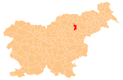
 Location of the Municipality of Zreče in Slovenia |
|
| Location of the town of Zreče in Slovenia | |
| Coordinates: 46°22′30.11″N 15°23′7.33″E / 46.3750306°N 15.3853694°ECoordinates: 46°22′30.11″N 15°23′7.33″E / 46.3750306°N 15.3853694°E | |
| Country |
|
| Government | |
| • Mayor | Boris Podvršnik |
| Area | |
| • Total | 67 km2 (26 sq mi) |
| Population (2008) | |
| • Total | 6,443 |
| • Density | 96/km2 (250/sq mi) |
| Time zone | CET (UTC+01) |
| • Summer (DST) | CEST (UTC+02) |
| Climate | Cfb |
| Website | www |
| Source: Statistical Office of the Republic of Slovenia, census of 2002. | |
Zreče (pronounced [ˈzɾeːtʃɛ]) is a town and a municipality in northeast Slovenia. It lies on the slopes of Pohorje in the upper valley of the Dravinja River. Traditionally the area was part of the Styria region. The municipality is now included in the Savinja Statistical Region. In 2002 it had a population of 6,245, growing to 6,443 according to the 2008 census. Zreče became a single settlement in 1987 when the villages of Zgornje Zreče, Spodnje Zreče, and Nova Dobrava (known as Dobrava until 1953) were united. The economy is centred on tourism, especially in the winter months with the ski resort at Rogla. A proportion of the population is also employed in agriculture.
Zreče is located 100 kilometres (62 miles) northeast of Ljubljana, 42 km (26 mi) from Maribor, 25 km (16 mi) from Celje and 4 km (2 mi) from Slovenske Konjice. The municipality covers an area of 67 square kilometres (26 square miles) at the foothills of the Pohorje range between 360 and 1517 metres above sea level. The central part of the municipality is highly segmented with much of the northern part with hills with an altitude of over 1,000 metres (3,281 feet) above sea level and a continental climate.
Archaeological evidence from the area has pointed to Neolithic settlement of the area. The earliest written sources date to the end of the 10th century when the area was divided into a number of ecclesiastical and secular domains.
The parish church in the settlement is dedicated to Saint Giles (Slovene: Sveti Egidij) and belongs to the Roman Catholic Archdiocese of Maribor. It dates to the 14th century with 18th and 19th century side chapels. Two churches on Mount Juniper (Brinjeva Gora) to the east of the settlement belong to the same parish. They are dedicated to Saint Agnes (Slovene: Sveta Neža), built between 1726 and 1732, and to the Virgin Mary, built in 1769.
...
Wikipedia

