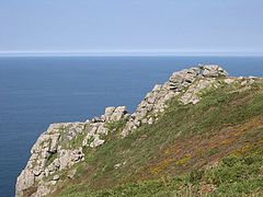
Zennor Head
| Zennor Head | |
|---|---|

Zennor Head, looking north
|
|
| Type | Promontory |
| Location | Cornwall |
| Nearest city | Zennor |
| Coordinates | 50°11′53″N 5°34′26″W / 50.198°N 5.574°WCoordinates: 50°11′53″N 5°34′26″W / 50.198°N 5.574°W |
| Etymology | Saint Senara |
| Operated by | National Trust |
Zennor Head /ˈzɛnʊər hɛd/ is a 750-metre (2,460 ft) long promontory on the Cornish coast of England, between Pendour Cove and Porthzennor Cove. Facing the Atlantic Ocean, it lies 1 kilometre north-west of the village of Zennor and 1.6 kilometres east of the next promontory, Gurnard's Head. The granite (Killas) cliffs rise over 200 feet (60 m) from the sea and the highest point of the headland is 314 feet (96 m) above sea level, with an Ordnance Survey triangulation station. Zennor Head is on the South West Coast Path, which follows the cliff edge closely, skirting the entire perimeter of the headland. The promontory is part of the Penwith Heritage Coast, and is the largest coastal feature in the United Kingdom that begins with the letter "Z". It gets its name from a local saint, Senara. Zennor Head was mined for copper and tin in the Victorian Era. There is no longer any residential or commercial occupancy on the headland, but it is occupied by a variety of coastal animals and plants, such as kestrels and gorse.
The name "Zennor Head" originates from the name of a local saint, Senara. According to local legend, Senara was thrown off a headland in Brittany in a barrel after being falsely accused of adultery by her husband and washed up on the Cornish coast, founding Zennor and giving her name to the eponymous village (and subsequently Zennor Head, Zennor Quoit and Porthzennor Cove), before continuing to Ireland. The "s" changed to a "z", an occurrence common in the West Country but rare elsewhere, and as such is the largest coastal feature in the United Kingdom to begin with the letter "Z".
...
Wikipedia
