Zeelandic Flanders
| Zeeuws-Vlaanderen | ||
|---|---|---|
| Region | ||
|
||
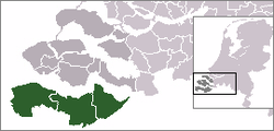
 Location of Zeelandic Flanders in Zeeland, Netherlands |
||
| Country | Netherlands | |
| Province | Zeeland | |
| Municipalities |
Sluis Terneuzen Hulst |
|
| Area | ||
| • Land | 733.19 km2 (283.09 sq mi) | |
| • Water | 142.61 km2 (55.06 sq mi) | |
| Population (31-12-2010) | 106.522 | |
| Major roads | N58, N60, N61, N62 (Western Scheldt Tunnel) | |
Zeelandic Flanders (Dutch: Zeeuws-Vlaanderen [ˌzeːu̯sˈflaːndərə(n)],Zeelandic: Zeêuws-Vlaonderen) is the southernmost region of the province of Zeeland in the south-western Netherlands. It lies south of the Western Scheldt that separates the region from the remainder of Zeeland to the north. Zeelandic Flanders is bordered to the south by Belgium.
Zeelandic Flanders is the north-eastern part of the large historical region of Flanders which today lies mostly in Belgium. It shares a land border with the Belgian provinces of East and West Flanders. It is a latitudinally oriented strip of land along the Western Scheldt, a North Sea estuary, and has no land access to the rest of the Netherlands. The area of Zeelandic Netherlands is 876 km2 (338 sq mi) of which 733 km2 (283 sq mi) is land and 143 km2 (55 sq mi) is water.
The region is bordered by the Zwin nature reserve in the West and the Drowned Land of Saeftinghe in the East.
Since local government boundary reforms in 2003, Zeelandic Flanders has consisted of only three municipalities: Sluis in the west, Terneuzen in the centre and Hulst in the east.
Zeelandic Flanders is connected to Flushing on Walcheren to the north of the Western Scheldt by the Western Scheldt Tunnel and the ferry it replaced which is now[update] for pedestrians and cyclists. A ferry that formerly ran from Perkpolder to Kruiningen in South Beveland was discontinued upon opening of the tunnel.
...
Wikipedia

