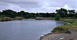
Yuna River
| Yuna River | |
| Río Yuna | |
| Country | Dominican Republic |
|---|---|
| Provinces | Monseñor Nouel, Sánchez Ramírez, Duarte, Samaná |
| Tributaries | |
| - left | Tireo River, Masipedro River, Yujo River, Camú River, Cuaba River, Nigua River, Yaiba River, Baiguate River, Azucey River, Guayabo River |
| - right | Yuboa River, Maimón River, Maguaca River, Chacuey River, Payabo River |
| Cities | Bonao, Cotuí |
| Source | Cerro Montoso Hill |
| - location | La Cuesta de la Vaca, Bonao, Monseñor Nouel, Dominican Republic |
| - elevation | 1,075 m (3,527 ft) |
| - coordinates | 18°47′16″N 70°25′05″W / 18.78778°N 70.41806°W |
| Mouth | Samaná Bay |
| - location | Los Haitises National Park, Sánchez, Samaná, Dominican Republic |
| - elevation | 0 m (0 ft) |
| - coordinates | 19°11′47″N 69°37′24″W / 19.19639°N 69.62333°WCoordinates: 19°11′47″N 69°37′24″W / 19.19639°N 69.62333°W |
| Length | 185.17 km (115.06 mi) |
| Basin | 5,498 km2 (2,122.8 sq mi) |
|
Map showing the Yuna drainage basin
|
|
The Yuna River (Spanish: Río Yuna) is the second longest river in the Dominican Republic at 185.17 km (115.06 miles) in length. It forms within the Cordillera Central mountain range southwest of the city of Bonao and passes through the fertile Cibao Valley. The river from there turns north-northeast passing the city of Bonao along the way. Southwest of Cotuí, the river reaches Hatillo Dam (Spanish: Presa de Hatillo) before turning northeast then east as it reaches its mouth at the Samaná Bay in the northeast part of the Dominican Republic. Like many rivers in the Dominican Republic, the name is derived from the Taíno language.
The source of the Yuna is located 78.95 km (49.06 miles) southeast of the city of Santiago and 62.41 km (38.78 miles) northwest of the city of Santo Domingo. The source is located near the southern Monseñor Nouel village of La Cuesta de la Vaca within the municipality of Bonao on Cerro Montoso Hill (Spanish: Loma de Cerro Montoso) at an elevation of 1,075 m (3,527 feet) above sea level. The Cerro Montoso Hill lies along the highest mountain range in the West Indies, the Cordillera Central. The Cordillera Central provides the principal watershed and drainage divide for the Dominican Republic; the Yuna has its source along the northern slope of the mountain range. The Yuna descends from its headwaters running south then west where several streams feed into the river near the San José de Ocoa province border. The Yuna then turns north near the village of El Torito passing through several mountains including Torito Hill (Spanish: La Loma del Torito), and Middle Hill (Spanish: La Loma El Medio). The Yuna shifts north-northwest near the Middle Hill passing through several villages including Pino de Yuna, Piedra de los Veganos, and El Capa.
...
Wikipedia


