Yuba River
| Yuba River | |
| Henneet, Rio De Los Yubas | |
|
At South Yuba River State Park
|
|
| Name origin: From the name of a Maidu village | |
| Country | United States |
|---|---|
| State | California |
| Region | Nevada County |
| Part of | Feather River basin |
| Tributaries | |
| - left | Middle Yuba River, South Yuba River, Deer Creek (Nevada County, California) |
| - right | North Yuba River |
| Cities | North San Juan, Marysville, Yuba City |
| Source | Confluence of North and Middle Yuba River |
| - location | Near North San Juan, Yuba/Nevada county line |
| - elevation | 1,129 ft (344 m) |
| - coordinates | 39°22′07″N 121°08′11″W / 39.36861°N 121.13639°W |
| Mouth | Feather River |
| - location | Yuba City-Marysville, Yuba County |
| - elevation | 49 ft (15 m) |
| - coordinates | 39°07′39″N 121°35′48″W / 39.12750°N 121.59667°WCoordinates: 39°07′39″N 121°35′48″W / 39.12750°N 121.59667°W |
| Length | 40 mi (64 km), Southeast or 115 miles (185 km) including the North Fork |
| Basin | 1,339 sq mi (3,468 km2) |
| Discharge | mouth |
| - average | 2,432 cu ft/s (69 m3/s) |
| - max | 180,000 cu ft/s (5,097 m3/s) |
| - min | 10 cu ft/s (0 m3/s) |
|
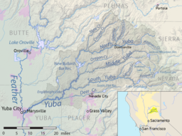
Map of the Yuba River basin
|
|
The Yuba River is a tributary of the Feather River in the Sierra Nevada and eastern Sacramento Valley, in the U.S. state of California.
The main stem of the river is about 40 miles (64 km) long, and its headwaters are split into North, Middle and South Forks. The confluence of the former two is considered the beginning of the Yuba River. The river drains about 1,339 square miles (3,470 km2) of the western slopes of the Sierra Nevada mountain range as well as a small portion of the Sacramento Valley. It contributes about a third of the flow of the Feather River, and almost 10 percent of the flow of the Sacramento River, which it ultimately drains into.
The river's name comes from a Maidu village, spelled in early records as Yubu and applied to the river by 1844. Some claim the name is a variant of Spanish uba or uva, referring to grapes found growing along the banks of the river.
Most of the Yuba River's flow is incorporated from its three main tributaries, the North Yuba, Middle Yuba and South Yuba. All three rivers run westwards from the crest of the Sierra Nevada to form the main stream of the Yuba. The beginning of the main stem is defined as the confluence of the North and Middle Yuba Rivers; the North Fork is longer.
The North Yuba River, 61.0 miles (98.2 km) long, rises near the eastern border of the Tahoe National Forest, on a mountainside along California State Route 49. It flows southwest then west through a 3,000-foot-deep (910 m) canyon past the small villages of Downieville, where it receives the Downie River, and Goodyears Bar. It then incorporates the flow of Canyon Creek and Slate Creek, two of its main tributaries, and very soon after widens into New Bullards Bar Reservoir, which is impounded by the 645-foot (197 m) New Bullards Bar Dam. Very soon after leaving the dam it joins with the Middle Yuba to form the Yuba River.
...
Wikipedia


