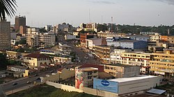
Youndé
| Yaoundé | |
|---|---|

Yaoundé, Cameroon
|
|
| Nickname(s): La Ville aux Sept Collines | |
| Map of Cameroon showing the location of Yaoundé. | |
| Coordinates: 3°52′N 11°31′E / 3.867°N 11.517°ECoordinates: 3°52′N 11°31′E / 3.867°N 11.517°E | |
| Region | Centre |
| Department | Mfoundi |
| Area | |
| • Total | 180 km2 (70 sq mi) |
| Elevation | 726 m (2,382 ft) |
| Population (2012) | |
| • Total | 2,440,462 |
| • Density | 14,000/km2 (35,000/sq mi) |
| Time zone | CET (UTC+1) |
| • Summer (DST) | CEST (UTC+1) |
Yaoundé (US: /ˌjɑːʊnˈdeɪ/, UK: /jɑːˈʊndeɪ, -ˈuːn-/;French pronunciation: [ja.unde]; German: Jaunde) is the capital of Cameroon and, with a population of approximately 2.5 million, the second largest city in the country after the port city Douala. It lies in the Centre Region of the nation at an elevation of about 750 metres (2,500 ft) above sea level.
The outpost of Epsumb or Jeundo was founded between the Nyong and Sanaga rivers at the northern edge of the area's forests in 1887, 1888, or February 1889 by the German explorers Lt. Kund and Tappenbeck by the agreement of the chiefs of Ela Esono. From December 1889 to May 1895, it was occupied by the German botanist Georg August Zenker as an agricultural research station named Jaunde after the local Yaunde or Ewondo people. His settlement served as a base for the area's rubber and ivory trade, purchasing these from the natives in exchange for imported clothing and iron. It was also known in English as Yaunde Station. Major Dominik's establishment of a military garrison at the site in 1895 permitted a Pallotine mission and religious school at nearby Mvolyé (now a suburb).
...
Wikipedia

