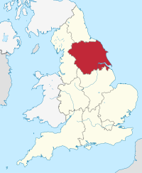
Yorkshire and Humberside
| Yorkshire and the Humber | |
|---|---|

Yorkshire and the Humber region in England
|
|
| Sovereign state | United Kingdom |
| Country | England |
| Status | Region |
| Government | |
| • EP constituency | Yorkshire and the Humber |
| Area | |
| • Total | 5,950 sq mi (15,420 km2) |
| Area rank | 5th |
| Population (2011) | |
| • Total | 5,284,000 |
| • Rank | 7th |
| • Density | 890/sq mi (340/km2) |
| GVA | |
| • Total | £101 billion |
| • Per capita | £16,880 (8th) |
| NUTS code | UKE |
| ONS code | E12000003 |
Yorkshire and the Humber is one of nine official regions of England at the first level of NUTS for statistical purposes. It comprises most of Yorkshire (South Yorkshire, West Yorkshire, the East Riding of Yorkshire including Hull, the shire county of North Yorkshire and the City of York), North Lincolnshire and North East Lincolnshire. It does not include Middlesbrough or Redcar and Cleveland (which are in the ceremonial county of North Yorkshire but not in the shire county). The population in 2011 was 5,284,000.
The committees for the regions, including the one for Yorkshire and the Humber, ceased to exist upon the dissolution of Parliament on 12 April 2010; they were not re-established by the newly elected House. Regional ministers were not reappointed by the incoming Coalition Government, and the Government Offices were abolished in 2011.
Scammonden Dam, is the highest dam in UK at 73 metres, and Dean Head cutting is the deepest roadway cutting in Europe at 183 ft, at Scammonden Bridge, on the M62. Sutton-under-Whitestonecliffe claims to be longest place name in England.
...
Wikipedia
