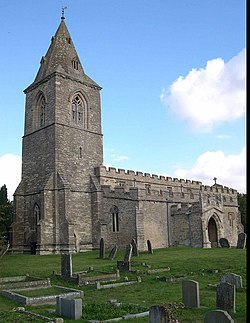
Yielden
| Yelden | |
|---|---|
 Yelden Church |
|
| Yelden shown within Bedfordshire | |
| OS grid reference | TL011746 |
| Civil parish | |
| Unitary authority | |
| Ceremonial county | |
| Region | |
| Country | England |
| Sovereign state | United Kingdom |
| Post town | BEDFORD |
| Postcode district | MK44 |
| Dialling code | 01933 |
| Police | Bedfordshire |
| Fire | Bedfordshire and Luton |
| Ambulance | East of England |
| EU Parliament | East of England |
| UK Parliament | |
Yielden or Yelden is a village in Bedfordshire, near the borders with Northamptonshire and Cambridgeshire. It lies on the River Til which feeds into the Great Ouse valley and is about 70m above sea level. It is approximately 14 miles north of Bedford, 3.75miles south-east of Higham Ferrers and 6.75 miles west of Kimbolton and is in the Hundred of Stodden. The countryside around the village rises to about 90m above sea level, is generally open and rolling in nature and is predominantly used for agricultural purposes. The centre piece of the village is the Castle Mound or Yielden Castle the site of a Norman motte-and-bailey castle. This is now a complex of grassed over earthworks dominated by a central mound. Other notable features include the church of St Mary, a Wesleyan Chapel built in 1884, the Chequers Public House and the Yelden Village Hall. It has a present population of roughly between 150 – 200 adults and 50 – 100 children living in about 90 residences. It is in the civil parish of Melchbourne and Yielden.
Yelden has its own book under the title 'Yelden Past and Present' produced by the Yelden Parish Study Group that was first printed in 1972. It has since been updated and reprinted in 2001 and is the definitive source of historical information about the village. Much of the information in this article has been made with reference to this publication.
Neighbouring villages include Melchbourne, Newton Bromswold, Upper Dean and Shelton.
Archaeological excavations carried out by Bedfordshire County Council along with other historical works have shown evidence of a near continuous occupation in the village dating back to the late Neolithic and early Bronze Age (c.2000 -800 BC). Latterly the village appeared in the Domesday Book of 1086 as 'Giveldene' where an account of its history was recorded.
This is a significant archaeological site and one of the most interesting of its type in the county. It was the site of a Norman Motte and Bailey Castle that from Domesday to the 13th century was the stronghold of the Trailly family. It is an imposing feature with a central conical mound rising to about 40 feet above the bottom of its north moat. It is in 2 levels with 2 extensive baileys and is not surrounded by a moat. There have been suggestions that prior to Norman times it was occupied by the Iceni, an ancient tribe of Britains and that they battled with the Romans at the site but opinions differ as to the accuracy of this assertion. In any event records show that by 1360 it had fallen in disuse and ruin.
...
Wikipedia

