Yeovil
| Yeovil | |
|---|---|
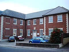
 Yeovil County Court |
|
| Yeovil shown within Somerset | |
| Population | 45,000 (2011) |
| OS grid reference | ST552164 |
| District | |
| Shire county | |
| Region | |
| Country | England |
| Sovereign state | United Kingdom |
| Post town | YEOVIL |
| Postcode district | BA20, BA21, BA22 |
| Dialling code | 01935 |
| Police | Avon and Somerset |
| Fire | Devon and Somerset |
| Ambulance | South Western |
| EU Parliament | South West England |
| UK Parliament | |
Yeovil (/ˈjoʊvɪl/ YOH-vil) is a town and civil parish in south Somerset, England with a population of 45,000. The town lies within the local district of South Somerset and the Yeovil parliamentary constituency, situated at the southern boundary of Somerset, 130 miles (210 km) from London, 40 miles (64 km) south of Bristol and 30 miles (48 km) from Taunton.
It has palaeolithic remains, was on an old Roman road and was left in the will of King Alfred the Great to his youngest son Aethelweard. In the Domesday Book it is recorded as the town of Givele or Ivle, and later became a centre for the glove-making industry. During the Middle Ages the population of the town suffered from the Black Death and several serious fires.
In the 20th century it developed into a centre of the aircraft and defence industries, which made it a target for bombing in the Second World War, with one of the largest employers being Westland Aircraft. Additionally, the Fleet Air Arm has a station RNAS Yeovilton (HMS Heron), the primary base of the Royal Navy's Westland Wildcat and Westland EH101 helicopters, several miles north of the town and is a major local employer (Ministry of Defence). Several other manufacturing and retail companies also have bases in the town. Plans have been proposed for various regeneration projects in the town.
...
Wikipedia

