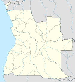
Xangongo
| Xangongo | |
|---|---|
| commune and town | |
 |
|
| Location in Angola | |
| Coordinates: 16°44′48″S 14°58′29″E / 16.74667°S 14.97472°E | |
| Country |
|
| Province | Cunene |
| Municipality | Ombadja |
| Time zone | WAT (UTC+1) |
| Climate | BSh |
Xangongo is a town and commune in the municipality of Ombadja, province of Cunene, Angola.
It is also the seat of that municipality and is located at around 16°44′48″S 14°58′29″E / 16.74667°S 14.97472°ECoordinates: 16°44′48″S 14°58′29″E / 16.74667°S 14.97472°E. It was also the site of considerable fighting in the war for the independence of Namibia (Southwest Africa) and the Angolan Civil War.
Xangongo was the headquarters of SWAPO's "northwestern front." A South African military operation called "Operation Protea" occurred on August 23, 1981. Its aim was to destroy SWAPO in the Angolan towns of Xangongo and Ondjiva. It was very successful and significantly boosted the South African military operations against both SWAPO and the Angolan military. The bridge over the Cunene River was destroyed by SADF Special Forces and the town was held for many years by South Africa. At the end of the Battle of Cuito Cuanavale the Fidel Castro 50th Brigade moved in and started harassing the withdrawing SADF forces, triggering Operation Excite/Hilti. In response to this harassment the SADF mobilized 81 Armoured Brigade in Operation Desert Fox, designed to neutralize the Cuban 50th Division, but this was not necessary because of the successful negotiations that ended the South African involvement in the Angolan Civil War.
...
Wikipedia

