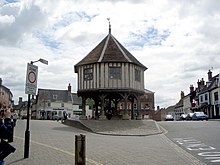
Wymondham
| Wymondham | |
|---|---|
 |
|
| Wymondham shown within Norfolk | |
| Area | 44.31 km2 (17.11 sq mi) |
| Population | 14,405 (2011. Census) |
| • Density | 325/km2 (840/sq mi) |
| OS grid reference | TG1101 |
| District | |
| Shire county | |
| Region | |
| Country | England |
| Sovereign state | United Kingdom |
| Post town | WYMONDHAM |
| Postcode district | NR18 |
| Dialling code | 01953 |
| Police | Norfolk |
| Fire | Norfolk |
| Ambulance | East of England |
| EU Parliament | East of England |
| UK Parliament | |
Wymondham /ˈwɪndəm/ is a historic market town and civil parish in the English county of Norfolk. It lies 9.5 miles (15 km) to the south west of the city of Norwich, just off the A11 road from Norwich to London which now by-passes the town. The parish includes large rural areas to the north and south of the town itself. It is the fourth largest civil parish in Norfolk.
Moot Hill
The earthworks of what was probably a large, medieval ringwork survive to some considerable height; they have been subject to ground survey and are partially visible on aerial photographs. The ringwork, which is located in an isolated part of the Stanfield estate, is thought by some to have been built by the D'Albinis between 1088 and 1139. The feature measures approximately 150m by 130m, with a large bank and water-filled ditch; the internal area also appears to be filled with irregular water-filled pits or ponds. It is thought that a gold ring of Katherine Bigot, wife of Roger Fitz-Ortet who held Stanfield Manor in AD 1306, was also recovered from this area.
Wymondham's most famous inhabitant was Robert Kett (or Ket), who led a rebellion in 1549 of peasants and small farmers in protest at the enclosure of common land. He took a force of almost unarmed men and fought for and held the City of Norwich for six weeks until defeated by the King's forces. He was hanged from Norwich Castle. Kett's Oak, said to be the rallying point for the rebellion, can still be seen today on the B1172 road between Wymondham and Hethersett, part of the former main road to London.
The Great Fire of Wymondham broke out on Sunday 11 June 1615. Two areas of the town were affected, implying there were two separate fires. One area was in Vicar Street and Middleton Street and the other in the Market Place, including Bridewell Street and Fairland Street. About 300 properties were destroyed in the fire. Important buildings destroyed included: the Market Cross, dating from 1286; the vicarage in Vicar Street; the 'Town Hall' on the corner of Middleton Street and Vicar Street; and the schoolhouse. However, many buildings such as the Green Dragon pub did survive and many of the houses in Damgate Street date back to 1400, although this is now masked by later brickwork.
...
Wikipedia

