
Wupatki National Monument
| Wupatki National Monument | |
|---|---|
|
IUCN category V (protected landscape/seascape)
|
|
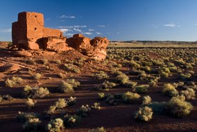
Wukoki ruins in 2008
|
|

|
|
| Location | Coconino County, Arizona, USA |
| Nearest city | Flagstaff, Arizona |
| Coordinates | 35°33′56″N 111°23′13″W / 35.56556°N 111.38694°WCoordinates: 35°33′56″N 111°23′13″W / 35.56556°N 111.38694°W |
| Area | 35,422 acres (143.35 km2) |
| Created | December 9, 1924 |
| Visitors | 216,165 (in 2011) |
| Governing body | National Park Service |
| Website | Wupatki National Monument |
The Wupatki National Monument is a U.S. National Monument located in north-central Arizona, near Flagstaff. Rich in Native American ruins, the monument is administered by the National Park Service in close conjunction with the nearby Sunset Crater Volcano National Monument. Wupatki was listed on the National Register of Historic Places on October 15, 1966. The listing included three contributing buildings and 29 contributing structures on 35,253.2 acres (14,266.5 ha).
The many settlement sites scattered throughout the monument were built by the Ancient Pueblo People, more specifically the Cohonina, Kayenta Anasazi, and Sinagua. Wupatki was first inhabited around 500 AD. Wupatki, which means "Tall House" in the Hopi language, is a multistory Sinagua pueblo dwelling comprising over 100 rooms and a community room and ball court, making it the largest building for nearly 50 miles. Nearby secondary structures have also been uncovered, including two kiva-like structures. A major population influx began soon after the eruption of Sunset Crater in the 11th century (between 1040 and 1100), which blanketed the area with volcanic ash; this improved agricultural productivity and the soil's ability to retain water. By 1182, approximately 85 to 100 people lived at Wupatki Pueblo but by 1225, the site was permanently abandoned. Based on a careful survey of archaeological sites conducted in the 1980s, an estimated 2000 immigrants moved into the area during the century following the eruption. Agriculture was based mainly on maize and squash raised from the arid land without irrigation. In the Wupatki site, the residents harvested rainwater due to the rarity of springs.
...
Wikipedia