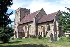
Woughton on the Green
| Old Woughton | |
|---|---|
 St Mary's parish church |
|
| Old Woughton shown within Buckinghamshire | |
| OS grid reference | SP875378 |
| Civil parish |
|
| Unitary authority | |
| Ceremonial county | |
| Region | |
| Country | England |
| Sovereign state | United Kingdom |
| Post town | MILTON KEYNES |
| Postcode district | MK6 |
| Dialling code | 01908 |
| Police | Thames Valley |
| Fire | Buckinghamshire |
| Ambulance | South Central |
| EU Parliament | South East England |
| UK Parliament | |
| Website | Old Woughton Parish Council website |
Old Woughton (/ˈwʊftən/ WUUF-tən) is a civil parish in south central Milton Keynes, ceremonial county of Buckinghamshire, England. The parish was established in April 2012 by the division into two parts of Woughton parish.
The parish was created following a campaign by residents of Woughton parish who petitioned Milton Keynes Borough Council in 2010. The Council originally rejected the proposals, however it agreed to instigate a further review. The proposal was reconsidered by Milton Keynes Council in November 2011 who decided to split the Woughton parish into two and establish a new parish from April 2012 The new parish was given the temporary name of 'Ouzel Valley' and elections to the parish council were held in May 2012. At the first meeting of the nine-member parish council on 9 May 2012 the name of Old Woughton Parish was adopted.
Parish elections were held in May 2012 and, at the first meeting of the nine-member parish council, the name of Old Woughton Parish was adopted.
The parish includes the areas of Woughton-on the Green, Woughton Park and Passmore. The boundaries of the parish run from the Netherfield Roundabout (H8/V8), south along the V8 (Marlborough Street) to a point where it intersects a redway north of Tinkers Bridge, then east along the redway to the Grand Union Canal, then south along the Canal to a point where it intersects H9 (Groveway), then along H9 (Groveway) to a point where it intersects the River Ouzel, then north along the River Ouzel to a point where it intersects H7 (Chaffron Way), then west along H7 (Chaffron Way) to a point where it intersects the Grand Union Canal, then south along the Grand Union Canal to a point where it intersects H8 (Standing Way), then west along H8 (Standing Way) to the Netherfield Roundabout (H8/V8).
...
Wikipedia

