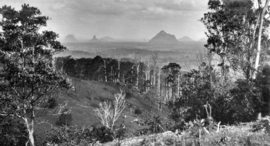
Wootha, Queensland
|
Wootha Queensland |
|||||||||||||||
|---|---|---|---|---|---|---|---|---|---|---|---|---|---|---|---|

Looking across Wootha towards the Glass House Mountains, circa 1931
|
|||||||||||||||
| Coordinates | 26°47′15″S 152°48′01″E / 26.7875°S 152.8002°ECoordinates: 26°47′15″S 152°48′01″E / 26.7875°S 152.8002°E | ||||||||||||||
| Postcode(s) | 4552 | ||||||||||||||
| Area | 18.1 km2 (7.0 sq mi) | ||||||||||||||
| LGA(s) | Sunshine Coast Region | ||||||||||||||
| State electorate(s) | Glass House | ||||||||||||||
| Federal Division(s) | Fisher | ||||||||||||||
|
|||||||||||||||
Wootha is a locality in the Sunshine Coast Region, Queensland, Australia.
The name Wootha comes from the Kabi language (Dallambara dialect) meaning red cedar tree.
Blackall Range Provisional School opened about 1886, becoming Blackall Range State School on 1 October 1909. It was renamed Wootha State School in 1937. It closed in 1949.
...
Wikipedia

