Wold Newton, Lincolnshire
| Wold Newton | |
|---|---|
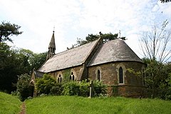
 All Hallows' Church, Wold Newton |
|
| Wold Newton shown within Lincolnshire | |
| Population | 337 (2011) |
| OS grid reference | TF243968 |
| • London | 135 mi (217 km) S |
| District | |
| Shire county | |
| Region | |
| Country | England |
| Sovereign state | United Kingdom |
| Post town | Market Rasen |
| Postcode district | LN8 |
| Police | Humberside |
| Fire | Humberside |
| Ambulance | East Midlands |
| EU Parliament | Yorkshire and the Humber |
| UK Parliament | |
Wold Newton is a village and civil parish in North East Lincolnshire, England. The population of the civil parish at the 2011 census was 337. It is situated just over 1 mile (1.6 km) west from the A18 road, 7 miles (11 km) north-west from Louth, and 9.5 miles (15 km) north-east from Market Rasen.
Although archaeological evidence and analysis of place names indicates millennia of settlement within the current parish boundary, the etymology of the name 'Wold Newton' dates the village to about the 8th century. It is therefore assumed that today's settlement began as a new Anglo Saxon farm in an otherwise largely Danish landscape. Coates' commentary on the place-names of Lincolnshire analyses the name 'Enschedik', the ancient name of a ditch running between the parishes of Wold Newton and Hawerby-cum-Beesby, and says that it is "tempting to regard it as a feature made when the 'new farm' of [Wold] Newton was inserted into an essentially Danish landscape".
The most significant archaeological discovery in Wold Newton was the discovery of Anglo Saxon urns in the field, Swinhope Walk, in 1828 by road workers quarrying gravel. The site was subsequently excavated by the Rev. Dr. Oliver, Vicar of Scopwick, Lincoln, who reported at a meeting of The Archaeological Institute the discovery of a:
large tumulus, spreading over about three acres, and composed entirely of gravel.... Upon this tumulus was ... a long barrow ... in which more than twenty urns, of various forms, had been deposited, arranged in a line, the whole length of the mound, the mouths upwards,. They lay about three feet from the surface, and at irregular distances, some being close together, others three or four feet apart. Three only were preserved, and they were sent ... to the Society of Antiquaries of Scotland. They were fabricated without the use of the lathe, and rudely scored with lines and circles; these urns were half filled with ashes, calcined bones, and black greasy earth. [He supposed] that this tumulus had been a family burying-place of some British chief, the larger mound being possibly the cemetery of his tribe.
English Heritage NMR Monument Reports record a range of possible historic sites within the parish from analysis of cropmarks. These include prehistoric or Roman enclosures; boundaries; trackways and the remains of a settlement consisting of tofts, crofts, buildings, boundaries hollow ways. English Heritage also records the finding of a Roman coin, a silver denarius of Trajan, dated to 114–117 AD.
Field walking in 1989 collected mediaeval and Roman pottery, and flint artefacts.
...
Wikipedia

