Wojkowice
| Wojkowice | |||
|---|---|---|---|

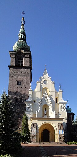
Church of Saint Anthony of Padua in Wojkowice
|
|||
|
|||
| Coordinates: 50°22′N 19°3′E / 50.367°N 19.050°E | |||
| Country |
|
||
| Voivodeship |
|
||
| County | Będzin | ||
| Gmina | Wojkowice (urban gmina) | ||
| Area | |||
| • City | 12.79 km2 (4.94 sq mi) | ||
| Population (2008) | |||
| • City | 9,368 | ||
| • Density | 730/km2 (1,900/sq mi) | ||
| • Urban | 2,746,000 | ||
| • Metro | 5,294,000 | ||
| Postal code | 42-580 | ||
| Website | http://www.wojkowice.pl | ||
Wojkowice [vɔi̯kɔˈvʲit͡sɛ] (German: Woikowize) is a small town in województwo śląskie, located in so-called Zagłębie Dąbrowskie in southern Poland, near Katowice. Wojkowice is located in the Silesian Highlands, on the Brynica river (tributary of the Vistula), and historically belongs to Lesser Poland. Its name comes from ancient Polish given name Wojek, which might have been a diminutive of Wojslaw. Several other locations in Poland have been named in a similar fashion – Wojslawice, Wojkowo, Wojkow, Wojkowa.
The town has used to be in Katowice Voivodeship, but has been part of the Silesian Voivodeship since its formation in 1999. Wojkowice is one of the cities of the 2,7 million conurbation – Katowice urban area and within a greater Silesian metropolitan area populated by about 5,294,000 people. The population of the town is 9,368 (2008).
Wojkowice borders the gmina of Bobrowniki, and the towns of Będzin (the district of Grodziec), Siemianowice Śląskie (the district of Przelajka), and Piekary Śląskie (the districts of Dąbrowka Wielka and Brzozowice-Kamien). In 2002, the area of the town was 12.77 km2 (4.93 sq mi), out of which arable land was 61%. Wojkowice in its current form was created on 31 December 1961, out of the merger of two settlements (called "colonies"): Wojkowice Komorne and Zychcice. On 18 July 1962, Wojkowice was granted town rights.
...
Wikipedia


