Wishram, Washington
| Wishram | |
|---|---|
| CDP | |

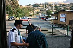
Passengers detraining at Wishram
|
|
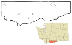
 Location of Wishram in Klickitat County, Washington |
|
| Coordinates: 45°39′40″N 120°57′32″W / 45.66111°N 120.95889°WCoordinates: 45°39′40″N 120°57′32″W / 45.66111°N 120.95889°W | |
| Country | United States |
| State | Washington |
| County | Klickitat |
| Area | |
| • Total | 1.3 sq mi (3.3 km2) |
| • Land | 1.3 sq mi (3.3 km2) |
| • Water | 0.0 sq mi (0.0 km2) |
| Elevation | 177 ft (54 m) |
| Population (2000) | |
| • Total | 213 |
| • Density | 254.2/sq mi (98.5/km2) |
| Time zone | Pacific (PST) (UTC-8) |
| • Summer (DST) | PDT (UTC-7) |
| ZIP code | 98673 |
| Area code(s) | 509 |
| FIPS code | 53-79485 |
| GNIS feature ID | 1528268 |
Wishram is a census-designated place (CDP) in Klickitat County, Washington, United States. The population was 213 at the 2000 census. The site of the historic Celilo Falls is nearby.
The community was originally named Fallbridge; it was changed to Wishram to honor the Wishram tribe of Native Americans. The nearby Dalles Dam was completed in 1957, and began filling Lake Celilo. The original fishing village near this location was inundated.
Wishram is located at 45°39′40″N 120°57′32″W / 45.66111°N 120.95889°W (45.661198, -120.958788).
According to the United States Census Bureau, the CDP has a total area of 1.3 square miles (3.3 km²), all of it land.
Wishram's location results from two major geological features: the location of the Celilo Falls on the Columbia River, and the access to the Central Oregon Plateau via the Deschutes River just across the falls from Wishram. The falls not only provided early peoples a reliable source of food, but it later provided a convenient location for an easily constructed railroad bridge crossing the Columbia. The Deschutes valley just to the south of the falls provided a route for rail access to the south, and ultimately to California.
Wishram lies toward the upper end of the Columbia River Gorge, which began forming as far back as the Miocene, (roughly 12 - 17 million years ago) depositing thick layers of Columbia River Basalt, and continued to take shape through the , (700,000 - 2 million years ago). During this period the Cascades Range was forming, slowly moving the Columbia River's course north to its current location.
...
Wikipedia
