Wirksworth
| Wirksworth | |
|---|---|
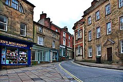
 Market Place |
|
| Wirksworth shown within Derbyshire | |
| Population | 5,038 (2011 census) |
| OS grid reference | SK2853 |
| District | |
| Shire county | |
| Region | |
| Country | England |
| Sovereign state | United Kingdom |
| Post town | MATLOCK |
| Postcode district | DE4 |
| Dialling code | 01629 |
| Police | Derbyshire |
| Fire | Derbyshire |
| Ambulance | East Midlands |
| EU Parliament | East Midlands |
| UK Parliament | |
Wirksworth is a market town in Derbyshire, England, with a population recorded as 5,038 in the 2011 census.
Wirksworth is listed in the Domesday Book of 1086. Within it is the source of the River Ecclesbourne. The town was granted its market charter by Edward I in 1306. The market is held every Tuesday in the market square. St Mary's Church is believed to date from about AD 653.
Historically, Wirksworth developed as a centre for lead mining and later of stone quarrying. Many of the lead mines in the area were owned by the Gell family of nearby Hopton Hall, and their name is preserved in the Via Gellia, a main road to the northwest of the town, and the Anthony Gell School.
The Wirksworth area may have been visited by Homo erectus as long as 150,000 years ago, during warm inter-glacial periods. An Acheulean handaxe from the Lower Paleolithic has been found at Hopton nearby. From other remains found in the county there would seem to have been human presence at least periodically until the Romans arrived.
In Roman Britain the limestone area of present-day Derbyshire was an important source of lead, with the primary area of production probably being around Lutudarum in the hills south and west of present-day Matlock. Wirksworth is one of the candidates for the site of Lutudarum. A possible Roman road led to a ford between Duffield and Milford and thence to Ryknild Street and the garrison at Derventio (Derby). In 2009 a team of volunteers excavated near the vicarage for a Roman fort, but failed to find evidence.
...
Wikipedia

