Winston, Georgia
| Winston, Georgia | |
|---|---|
| Unincorporated community | |
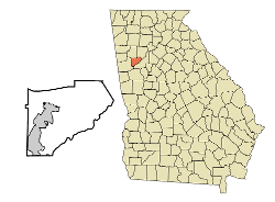
 Location in Douglas County and the state of Georgia |
|
| Coordinates: 33°43′48″N 84°51′36″W / 33.73000°N 84.86000°WCoordinates: 33°43′48″N 84°51′36″W / 33.73000°N 84.86000°W | |
| Country |
|
| State |
|
| County | Douglas |
| Elevation | 364.8 m (1,197 ft) |
| Time zone | Eastern (EST) (UTC-5) |
| • Summer (DST) | EDT (UTC-4) |
| ZIP code | 30187 |
| Area code(s) | 770 |
Winston is an unincorporated community, formerly incorporated as a city, in southwestern Douglas County, Georgia, United States.
Winston is assigned the United States Postal Service ZIP code 30187. ZIP Code 30187 has segments in two counties, Carroll and Douglas.
Winston is located at 33°44′N 84°52′W / 33.73°N 84.86°W which is 33°43′48″N 84°51′36″W / 33.73000°N 84.86000°W.
The following lakes, streams, and summits are in the vicinity of Winston:
Andy Mountain is a mountain summit in Douglas County in the state of Georgia (GA). Andy Mountain climbs to 1,329 feet (405.08 meters) above sea level. Andy Mountain is located at latitude - longitude coordinates (also called lat - long coordinates or GPS coordinates) of N 33.730941 and W -84.853828. Anyone attempting to climb Andy Mountain and reach the summit should look for detailed information on the Andy Mountain area in the topographic map (topo map) and the Winston USGS quad. To hike and explore the Georgia outdoors near Andy Mountain, check the list of nearby trails.
Cedar Mountain is a mountain summit in Douglas County in the state of Georgia (GA). Cedar Mountain climbs to 1,243 feet (378.87 meters) above sea level. Cedar Mountain is located at latitude - longitude coordinates (also called lat - long coordinates or GPS coordinates) of N 33.748719 and W -84.805771. Anyone attempting to climb Cedar Mountain and reach the summit should look for detailed information on the Cedar Mountain area in the topographic map (topo map) and the Winston USGS quad. To hike and explore the Georgia outdoors near Cedar Mountain, check the list of nearby trails.
...
Wikipedia
