Winnemucca Municipal Airport
| Winnemucca Municipal Airport | |||||||||||||||
|---|---|---|---|---|---|---|---|---|---|---|---|---|---|---|---|

Airport entrance and sign
|
|||||||||||||||
| Summary | |||||||||||||||
| Airport type | Public | ||||||||||||||
| Owner | City/County | ||||||||||||||
| Serves | Winnemucca, Nevada | ||||||||||||||
| Location | Humboldt County, Nevada | ||||||||||||||
| Elevation AMSL | 4,308 ft / 1,313 m | ||||||||||||||
| Coordinates | 40°53′48″N 117°48′21″W / 40.89667°N 117.80583°WCoordinates: 40°53′48″N 117°48′21″W / 40.89667°N 117.80583°W | ||||||||||||||
| Maps | |||||||||||||||
 |
|||||||||||||||
| Location in Nevada | |||||||||||||||
| Runways | |||||||||||||||
|
|||||||||||||||
| Helipads | |||||||||||||||
|
|||||||||||||||
| Statistics (2012) | |||||||||||||||
|
|||||||||||||||
|
Source: Federal Aviation Administration
|
|||||||||||||||
| Aircraft operations | 25,575 |
|---|---|
| Based aircraft | 34 |
Winnemucca Municipal Airport (IATA: WMC, ICAO: KWMC, FAA LID: WMC) is six miles southwest of Winnemucca, in Humboldt County, Nevada.
The National Plan of Integrated Airport Systems for 2011–2015 categorized it as a general aviation facility.
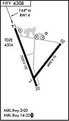
The airport covers 968 acres (392 ha) at an elevation of 4,308 feet (1,313 m). It has two asphalt runwas: 14/32 is 7,000 by 100 feet (2,134 x 30 m) and 2/20 is 4,800 by 75 feet (1,463 x 23 m). It has two concrete helipads (H1 and H2) each 25 by 25 feet (8 x 8 m).
In the year ending June 30, 2012 the airport had 25,575 aircraft operations, average 70 per day: 94% general aviation, 6% air taxi, and <1% military. 34 aircraft were then based at this airport: 94% single-engine and 6% multi-engine.
...
Wikipedia

