Wing, Buckinghamshire
| Wing | |
|---|---|
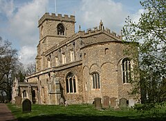
 All Saints' parish church |
|
| Wing shown within Buckinghamshire | |
| Population | 2,745 (2011 Census including Ascott) |
| OS grid reference | SP882229 |
| Civil parish |
|
| District | |
| Shire county | |
| Region | |
| Country | England |
| Sovereign state | United Kingdom |
| Post town | Leighton Buzzard |
| Postcode district | LU7 |
| Dialling code | 01296 |
| Police | Thames Valley |
| Fire | Buckinghamshire |
| Ambulance | South Central |
| EU Parliament | South East England |
| UK Parliament | |
| Website | Wing Village |
Wing, known in antiquated times as Wyng, is a village and civil parish in Aylesbury Vale district in Buckinghamshire, England. The village is on the main A418 road between Aylesbury and Leighton Buzzard. It is about 8 miles (13 km) north east of Aylesbury, 3 miles (5 km) west of Leighton Buzzard, and 12 miles (19 km) south of Milton Keynes.
The Domesday Book of 1086 records the toponym as Witehunge. The name occurs in Old English circa 966–975 as Weowungum (dative plural case). It could mean:
The first syllables of the names of the nearby village of Wingrave and the nearby hamlet of Wingbury have the same etymology.
The remains of the temple referred to may be under the Anglo-Saxon Church of England parish church of All Saints. The BBC programme Meet the Ancestors came to Wing in 2000 and recreated the face of an Anglo-Saxon girl found buried in the old graveyard. Wing has the oldest continuously used religious site in the country, with evidence showing the site has had religious use going back well over 1300 years. The Anglo-Saxon origin of All Saints' parish church makes it one of the oldest churches in England.
An ancient track, part of the pre-historic Icknield Way linking Oxford with Cambridge, once passed through the village. This was used in the Middle Ages and led to an increase in the village's size, though with the advent of modern roads and motorways this is less used today.
...
Wikipedia

