Windsor, Queensland
|
Windsor Brisbane, Queensland |
|||||||||||||
|---|---|---|---|---|---|---|---|---|---|---|---|---|---|

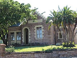
Windsor Shire Council Chambers, later Windsor Town Council Chambers.
|
|||||||||||||
| Coordinates | 27°26′S 153°02′E / 27.433°S 153.033°ECoordinates: 27°26′S 153°02′E / 27.433°S 153.033°E | ||||||||||||
| Population | 6,389 (2011 census) | ||||||||||||
| • Density | 2,200/km2 (5,710/sq mi) | ||||||||||||
| Postcode(s) | 4030 | ||||||||||||
| Area | 2.9 km2 (1.1 sq mi) | ||||||||||||
| Location | 3 km (2 mi) from Brisbane CBD | ||||||||||||
| LGA(s) |
City of Brisbane (Enoggera Ward;Hamilton Ward;Marchant Ward) |
||||||||||||
| State electorate(s) | Brisbane Central | ||||||||||||
| Federal Division(s) | Brisbane | ||||||||||||
|
|||||||||||||
Windsor is an inner northern suburb of Brisbane, Queensland, Australia, located about 3.5 kilometres (2.2 mi) from the Brisbane central business district. It is largely residential, featuring many old Queenslanders, although there is also considerable retail commercial activity, primarily concentrated along Lutwyche and Newmarket Roads.
In the 2011 census, Windsor had a population of 6,389 people; 49.1% female and 50.9% male. The median age of the Windsor population was 33 years, 4 years below the Australian median. Children aged under 15 years made up 15.9% of the population and people aged 65 years and over made up 9.2% of the population. 71.9% of people living in Windsor were born in Australia, compared to the national average of 69.8%. The other top responses for country of birth were England 3.5%, New Zealand 3.4%, India 3%, Italy 1.4%, Nepal 1%. 82.7% of people spoke only English at home; the next most popular languages were 2.2% Italian, 1% Mandarin, 0.9% Nepali, 0.8% Punjabi, 0.8% Hindi.
Land was first sold in this remote part of then New South Wales in 1854 and development was slow until the opening of the Bowen Bridge in 1860, named after the newly arrived first governor of Queensland, Sir George Bowen, allowing easier access to the district. At that time the district was known as Breakfast Creek or Upper Breakfast Creek. Distinctive homes including Rosemount, Oakwal, The Bower, Wilston House and Eildon were built on large portions of land.
In 1864, pioneer settlers approached the Government for aid to establish a local school. "The Bowen Bridge Road National School" consisted of a simple wooden building and headmaster's house erected on a stone foundation and opened on 17 July 1865 on Bowen Bridge Road, adjacent to Thondley's Farm. Sixteen students enrolled for the first day and by the end of the first year, 112 students were on the register. In 1915, the school transferred across the road and was renamed "Windsor State School". After World War I, the original school and headmaster's house was demolished and the land developed as the Windsor Memorial Park upon which a war memorial was constructed.
Swan Hill, O'Connell Town, Eildon, Albion, and Lutwyche were locality names before the appearance of the Windsor name when the shire council was formed.
...
Wikipedia

