Wilmot, New Hampshire
| Wilmot, New Hampshire | ||
|---|---|---|
| Town | ||

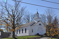
Wilmot Baptist Church, in Wilmot Flat
|
||
|
||
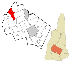
 Location in Merrimack County and the state of New Hampshire. |
||
| Coordinates: 43°27′03″N 71°54′48″W / 43.45083°N 71.91333°WCoordinates: 43°27′03″N 71°54′48″W / 43.45083°N 71.91333°W | ||
| Country | United States | |
| State | New Hampshire | |
| County | Merrimack | |
| Incorporated | 1794 | |
| Government | ||
| • Board of Selectmen | Nick Brodich, Chair Mary Kay Huntoon Thomas Schamberg |
|
| Area | ||
| • Total | 29.8 sq mi (77.1 km2) | |
| • Land | 29.6 sq mi (76.5 km2) | |
| • Water | 0.2 sq mi (0.6 km2) 0.74% | |
| Elevation | 873 ft (266 m) | |
| Population (2010) | ||
| • Total | 1,358 | |
| • Density | 46/sq mi (18/km2) | |
| Time zone | Eastern (UTC-5) | |
| • Summer (DST) | Eastern (UTC-4) | |
| ZIP code | 03287 | |
| Area code(s) | 603 | |
| FIPS code | 33-84900 | |
| GNIS feature ID | 0873755 | |
| Website | www.wilmotnh.org | |
Wilmot is a town in Merrimack County, New Hampshire, United States. The population was 1,358 at the 2010 census. Wilmot is home to Winslow State Park and a small part of Gile State Forest. The town includes the villages of Wilmot, Wilmot Flat, and North Wilmot.
Incorporated in 1807 from part of New London, the town took its name from Dr. James Wilmot, an English clergyman who had spoken out against England's treatment of the American colonies. Dr. Wilmot was rector at Barton-on-Heath in Warwickshire, England.
Wilmot is in northwestern Merrimack County, in the Dartmouth–Lake Sunapee Region of New Hampshire. According to the United States Census Bureau, the town has a total area of 29.8 square miles (77.2 km2), of which 29.5 sq mi (76.4 km2) is land and 0.2 sq mi (0.5 km2), or 0.74%, is water. Wilmot is drained by the Blackwater River and Kimpton Brook.
The village of Wilmot is near the center of the town and is along New Hampshire Route 4A. Wilmot Flat is a village in the southern part of the town, served by New Hampshire Route 11. North Wilmot is a rural community centered on the junction of North Wilmot Road and Hobbs Hill Road, north of White Pond.
Mount Kearsarge, elevation 2,931 feet (893 m) above sea level, on the southeastern border, is the highest point in town. Winslow State Park, at the northern foot of the mountain, provides access by two hiking trails to the summit. The state park and the Winslow Trail are named after Captain John Winslow, the commander of the USS Kearsarge, which in June 1864 sank the CSS Alabama in the English Channel in a famous Civil War sea battle.
...
Wikipedia

