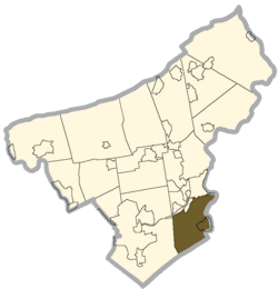
Williams Township, Northampton County, Pennsylvania
| Williams Township | |
|---|---|
| Township | |

|
|
 Location of Williams Township in Northampton County |
|
| Pennsylvania | |
| Coordinates: 40°38′00″N 75°13′59″W / 40.63333°N 75.23306°WCoordinates: 40°38′00″N 75°13′59″W / 40.63333°N 75.23306°W | |
| Country | United States |
| State | Pennsylvania |
| County | Northampton |
| Area | |
| • Total | 18.7 sq mi (48 km2) |
| • Land | 18.4 sq mi (48 km2) |
| • Water | 0.3 sq mi (0.8 km2) |
| Elevation | 643 ft (196 m) |
| Population (2000) | |
| • Total | 4,470 |
| • Density | 240/sq mi (92/km2) |
| Time zone | EST (UTC-5) |
| • Summer (DST) | EDT (UTC-4) |
| Area code(s) | 610 |
| Website | http://www.williamstwp.org |
Williams Township is a township in Northampton County, Pennsylvania, United States. Williams Township is located in the Lehigh Valley region of the state.
The population of Williams Township was 4,470 at the 2000 census.
The Bridge in Williams Township, Jacob Arndt House and Barn, Coffeetown Grist Mill, and Isaac Stout House are listed on the National Register of Historic Places. Another historic grist mill located in Williams Township is the Wottring Mill built in 1810 by William Wottring located on a road that is named in honor of William's mill on Wottrings Mill Road. Presently, it is an unregistered historic place that is privately owned.
According to the United States Census Bureau, Williams Township has a total area of 18.7 square miles (48.5 km2), of which, 18.4 square miles (47.6 km2) of it is land and 0.3 square miles (0.9 km2) of it (1.76%) is water. It is drained by the Delaware River, which separates it on the east from New Jersey. Interstate 78 crosses east-to-west in the north and its Easton interchange is with Old Philadelphia Road/Morgan Hill Road in the township. Route 611 follows the river from Martins Creek via Easton to Kinternsville. It is connected to the 78 interchange by Cedarville Road. Other notable local roads are Durham Road, Hellertown-Raubsville Road, and Island Park Road. Its villages include Coffeetown, Raubsville, and Stouts.
As of the census of 2000, there were 4,470 people, 1,657 households, and 1,267 families residing in the township. The population density was 243.0 people per square mile (93.8/km2). There were 1,738 housing units at an average density of 94.5/sq mi (36.5/km2). The racial makeup of the township was 97.25% White, 0.81% African American, 0.04% Native American, 0.94% Asian, 0.02% Pacific Islander, 0.13% from other races, and 0.81% from two or more races. Hispanic or Latino of any race were 1.05% of the population.
...
Wikipedia

