Wild River State Park
| Wild River State Park | |
| Minnesota State Park | |
|
Wild River State Park protects shoreline along the St. Croix, a National Wild and Scenic River
|
|
| Country | United States |
|---|---|
| State | Minnesota |
| County | Chisago |
| Location | Almelund |
| - elevation | 774 ft (236 m) |
| - coordinates | 45°34′5″N 92°52′33″W / 45.56806°N 92.87583°WCoordinates: 45°34′5″N 92°52′33″W / 45.56806°N 92.87583°W |
| Area | 6,574 acres (2,660 ha) |
| Founded | 1973 |
| Management | Minnesota Department of Natural Resources |
|
Point Douglas to Superior Military Road: Deer Creek Section
|
|

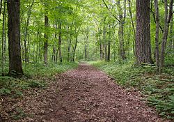
Park trail following the route of the Point Douglas to Superior Military Road
|
|
| Location | Amador Township |
|---|---|
| Coordinates | 45°30′22″N 92°43′4″W / 45.50611°N 92.71778°W |
| Area | 2.2 acres (0.9 ha) |
| Built | 1853 |
| Architect | James Hervey Simpson (engineer), John Rollins (builder) |
| Architectural style | earth road |
| MPS | Minnesota Military Roads, 1850–1857 |
| NRHP Reference # | 90002200 |
| Added to NRHP | 1991-02-07 |
Wild River State Park is a state park of Minnesota, United States, curving along 18 miles (29 km) of the St. Croix River. This long, narrow park is shaped somewhat like a sideways 'S', with development largely concentrated in the lower third. The remote upper sections flank the mouth of a tributary called the Sunrise River. The park is managed to provide quieter, more nature-oriented recreation as a counterpoint to the busier William O'Brien and Interstate State Parks downstream.
Wild River State Park is named after the St. Croix's designation as a National Wild and Scenic River. The park contains the Point Douglas to Superior Military Road: Deer Creek Section, a surviving section of the Point Douglas to Superior Military Road built in 1853, which is listed on the National Register of Historic Places.
The bedrock of the park is basalt formed by volcanic activity 1.1 billion years ago. This is overlain by a thick layer of glacial debris. During the Wisconsin glaciation 16,000 years ago, a small glacial lobe branched northeast off the Des Moines Lobe, blocking drainage from farther north. Water backed up into Glacial Lake Grantsburg. The soil in the park is quite sandy from the sediments that accumulated in this now-vanished lake. At the end of this ice age 10,000 years ago, meltwater flowing out of Glacial Lake Duluth carved the St. Croix River Valley. Today the river is one hundred times smaller than its glacial maximum. The ancient bank of the river is a bluff running through the park, well back from the current riverbed.
This area was originally a transition zone between pine forest, hardwood forest, and oak savanna. These habitats were disrupted by logging and farming. Today the park is a mix of second-growth forest and meadow. As the river tends to overflow its banks in spring, inundation-tolerant species like silver maple and basswood dominate the floodplain. Wetlands are scattered throughout the park. Berries are prevalent along the trails, as are wild roses. Each month throughout spring and summer brings different wildflowers in bloom. Some common spring flowers include wild columbine (Aquilegia canadensis), wild geranium (Geranium maculatum), and Carolina puccoon (Lithospermum caroliniense). During the summer, visitors can see black-eyed Susan (Rudbeckia hirta), butterfly milkweed (Asclepias tuberosa), and rough blazing star (Liatris aspera). Fall brings its own mix of wildflowers, including many asters and goldenrods. There is also a variety of native grasses, including big bluestem (Andropogon gerardi), little bluestem (Schizachyrium scoparium), and Indian grass (Sorghastrum nutans).
...
Wikipedia


