Wil, Switzerland
| Wil | ||
|---|---|---|

View of old town with the Hof in the centre
|
||
|
||
| Coordinates: 47°28′N 9°03′E / 47.467°N 9.050°ECoordinates: 47°28′N 9°03′E / 47.467°N 9.050°E | ||
| Country | Switzerland | |
| Canton | St. Gallen | |
| District | Wahlkreis Wil | |
| Government | ||
| • Executive |
Stadtrat with 5 members |
|
| • Mayor |
Stadtpräsident (list) Susanne Hartmann CVP/PDC (as of March 2014) |
|
| • Parliament |
Stadtparlament with 45 members |
|
| Area | ||
| • Total | 20.82 km2 (8.04 sq mi) | |
| Elevation | 571 m (1,873 ft) | |
| Population (Dec 2015) | ||
| • Total | 23,667 | |
| • Density | 1,100/km2 (2,900/sq mi) | |
| Postal code | 9500 | |
| SFOS number | 3427 | |
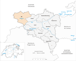
| Surrounded by | Bronschhofen, Jonschwil, Münchwilen (TG), Rickenbach (TG), Sirnach (TG), Uzwil (SG), Wilen (TG), Zuzwil | |
| Twin towns | Dobrzen Wielki (Poland) | |
| Website |
www SFSO statistics |
|
Wil is the capital of the Wahlkreis (constituency) of Wil in the canton of St. Gallen in Switzerland.
Wil is the third largest city in the Canton of St. Gallen, after the city of St. Gallen and Rapperswil-Jona, a twin city that merged in 2006. The municipality of Bronschhofen merged into Wil on 1 January 2013. After the merger the Community Identification Number changed from 3425 to 3427.
In 1984, Wil was awarded the Wakker Prize for the development and preservation of its architectural heritage.
Since the merger in 2013, Wil now has an area of 20.82 km2 (8.04 sq mi). Based on the 2004/09 survey, but including the post-merger area, about 50.1% of the total land is used for agricultural purposes, while 18.9% is forested. Of the rest of the land, 30.1% is settled (buildings or roads) and 0.9% is unproductive land. Over the past two decades (1979/85-2004/09) the amount of land that is settled has increased by 111 ha (270 acres) and the agricultural land has decreased by 113 ha (280 acres).
Before the merger, Wil had an area, as of 2006[update], of 7.6 km2 (2.9 sq mi). Of this area, 32.1% is used for agricultural purposes, while 13.9% is forested. Of the rest of the land, 53.4% is settled (buildings or roads) and the remainder (0.7%) is non-productive (rivers or lakes).
The former municipality of Bronschhofen had an area, as of 2006[update], of 13.2 km2 (5.1 sq mi). Of this area, 65.3% is used for agricultural purposes, while 22.1% is forested. Of the rest of the land, 12% is settled (buildings or roads) and the remainder (0.5%) is non-productive (rivers or lakes). It consisted of the villages of Bronschhofen and Rossrüti as well as the hamlets of Maugwil, Trungen and the pilgrimage site of Dreibrunnen.
...
Wikipedia


