Wichita Mid-Continent Airport
| Wichita Dwight D. Eisenhower National Airport | |||||||||||||||||||
|---|---|---|---|---|---|---|---|---|---|---|---|---|---|---|---|---|---|---|---|

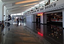
Interior view of the Wichita Dwight D. Eisenhower National Airport which opened June 3, 2015.
|
|||||||||||||||||||
 |
|||||||||||||||||||
| Summary | |||||||||||||||||||
| Airport type | Public | ||||||||||||||||||
| Owner | City of Wichita | ||||||||||||||||||
| Operator | Wichita Airport Authority | ||||||||||||||||||
| Serves | Southern Kansas | ||||||||||||||||||
| Location | Wichita, Kansas, U.S. | ||||||||||||||||||
| Elevation AMSL | 1,333 ft / 406.3 m | ||||||||||||||||||
| Coordinates | 37°39′0″N 97°25′59″W / 37.65000°N 97.43306°WCoordinates: 37°39′0″N 97°25′59″W / 37.65000°N 97.43306°W | ||||||||||||||||||
| Website | flywichita.com | ||||||||||||||||||
| Map | |||||||||||||||||||
 |
|||||||||||||||||||
| Runways | |||||||||||||||||||
|
|||||||||||||||||||
| Statistics (2014) | |||||||||||||||||||
|
|||||||||||||||||||
| Passengers | 736,220 |
|---|
Wichita Dwight D. Eisenhower National Airport (IATA: ICT, ICAO: KICT, FAA LID: ICT) is a commercial airport located about 7 miles (11 km) west of downtown Wichita, Kansas, United States. It is the largest and busiest airport in the state of Kansas.
The airport is commonly referred to as Eisenhower National Airport although most locals call it Wichita Airport.
The airport was previously Wichita Mid-Continent Airport. The name was to be changed on March 31, 2015 by the city of Wichita, but the official change occurred within the Federal Aviation Administration (FAA) on November 13, 2014 for a deadline to publish new aeronautical charts and airport directories. The new terminal opened on Wednesday, June 3, 2015.
The airport is named for Dwight David "Ike" Eisenhower (pronounced EYE-zən-how-ər), the 34th President of the United States from 1953 to 1961. His boyhood home, museum, and Presidential Library are at the Eisenhower Presidential Center in Abilene, Kansas.
Over the past 90+ years the largest airport in Wichita has had three major terminals, including the moving of its location from the southeast to southwest side of the city.
...
Wikipedia


