Whidbey Island, Washington
| Nickname: "The Rock" | |
|---|---|

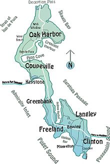
Map of Whidbey Island
|
|
| Geography | |
| Location | Puget Sound |
| Coordinates | 48°08′11″N 122°34′57″W / 48.136389°N 122.5825°WCoordinates: 48°08′11″N 122°34′57″W / 48.136389°N 122.5825°W |
| Area | 168.67 sq mi (436.9 km2) |
| Length | 58 mi (93 km) |
| Width | 12 mi (19 km) |
| Administration | |
|
United States
|
|
| State | Washington |
| County | Island County |
| Largest settlement | Oak Harbor (pop. 23,204 ) |
| Demographics | |
| Population | 58,211 |
| Pop. density | 133.25 /km2 (345.12 /sq mi) |
Whidbey Island (historical spellings Whidby, Whitbey, or Whitby) is the largest of the islands composing Island County, Washington, in the United States. (The other large island is Camano Island, east of Whidbey.) Whidbey is about 30 miles (48 km) north of Seattle, and lies between the Olympic Peninsula and the I-5 corridor of western Washington. The island forms the northern boundary of Puget Sound. It is home to Naval Air Station Whidbey Island.
Whidbey Island is home to 58,211 residents (according to the 2000 census). An estimated 29,000 of Whidbey Island residents live in rural locations.
Whidbey Island is approximately 55 miles (89 km) long (from the extreme north to extreme south), and 1.5 to 12 miles (2.4 to 19.3 km) wide, with a total land area of 168.67 square miles (436.9 km2), making it the 40th largest island in the United States. It is ranked as the fourth longest and fourth largest island in the contiguous United States, behind Padre Island, Texas (the world's longest barrier island); Long Island; and Isle Royale, Michigan. In the state of Washington, it is the largest island, followed by Orcas Island.
Whidbey Island was once inhabited by members of the Lower Skagit, Swinomish, Suquamish, Snohomish and other Native American tribes. Their name for the island was Tscha-kole-chy. The Native Americans were peaceful groups who lived off the sea and land, with fishing, harvesting nuts, berries and roots, which they preserved over the winter.
...
Wikipedia

