Westmoreland, New Hampshire
| Westmoreland, New Hampshire | |
|---|---|
| Town | |

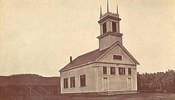
Union Church c. 1915
|
|
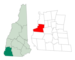
 Location in Cheshire County, New Hampshire |
|
| Coordinates: 42°57′43″N 72°26′32″W / 42.96194°N 72.44222°WCoordinates: 42°57′43″N 72°26′32″W / 42.96194°N 72.44222°W | |
| Country | United States |
| State | New Hampshire |
| County | Cheshire |
| Incorporated | 1752 |
| Government | |
| • Board of Selectmen | Russ Austin, Chair Jack Zeller Clayton Stalker |
| • Town Administrator | Jo Ann LaBarre |
| Area | |
| • Total | 36.9 sq mi (95.5 km2) |
| • Land | 35.9 sq mi (92.9 km2) |
| • Water | 1.0 sq mi (2.6 km2) 2.71% |
| Elevation | 417 ft (127 m) |
| Population (2010) | |
| • Total | 1,874 |
| • Density | 51/sq mi (20/km2) |
| Time zone | Eastern (UTC-5) |
| • Summer (DST) | Eastern (UTC-4) |
| ZIP code | 03467 |
| Area code(s) | 603 |
| FIPS code | 33-82660 |
| GNIS feature ID | 0873753 |
| Website | www |
Westmoreland is a town in Cheshire County, New Hampshire, United States. The population was 1,874 at the 2010 census. Westmoreland is historically an agricultural town, with much arable farmland.
Once known as Great Meadow, this town was first granted in 1735 by Governor Jonathan Belcher of Massachusetts as Number 2, second in a line of Connecticut River fort towns designed to protect the colonies from Indian attack. This part of the river was a favorite Indian campsite, and the settlers who came beginning in 1741 were several times victims of attack. When the border between Massachusetts and the Province of New Hampshire was fixed (with Number 2 on the New Hampshire side), the town was regranted in 1752 by Governor Benning Wentworth as Westmoreland, named for John Fane, 7th Earl of Westmorland.
The Park Hill Meetinghouse, built in 1762, has a Paul Revere bell. Considered one of the most beautiful churches in New England, it was moved to its present site by oxen in 1779, and renovated in 1826.
According to the United States Census Bureau, the town has a total area of 36.9 square miles (95.6 km2), of which 35.9 sq mi (93.0 km2) is land and 1.0 sq mi (2.6 km2), or 2.71%, is water. Westmoreland is bounded on the west by the Connecticut River. Hyland Hill, elevation 1,510 feet (460 m) above sea level and the highest point in town, is on the eastern border and although it is now private land, it is a local hiking and hunting destination.
...
Wikipedia
