Westcliffe, Colorado
| Westcliffe, Colorado | |
|---|---|
| Town | |

Sangre de Cristo Range viewed from Westcliffe
|
|
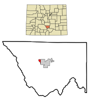
 Location in Custer County and the state of Colorado |
|
| Coordinates: 38°7′58″N 105°27′57″W / 38.13278°N 105.46583°WCoordinates: 38°7′58″N 105°27′57″W / 38.13278°N 105.46583°W | |
| Country |
|
| State |
|
| County | Custer County - seat |
| Incorporated | November 21, 1887 |
| Government | |
| • Type | Statutory Town |
| • Mayor | Christy Patterson |
| Area | |
| • Total | 1.2 sq mi (3.2 km2) |
| • Land | 1.2 sq mi (3.2 km2) |
| • Water | 0 sq mi (0 km2) |
| Elevation | 7,867 ft (2,398 m) |
| Population (2010) | |
| • Total | 568 |
| • Density | 455/sq mi (175.7/km2) |
| Time zone | Mountain (MST) (UTC-7) |
| • Summer (DST) | MDT (UTC-6) |
| ZIP code | 81252 |
| Area code(s) | 719 |
| FIPS code | 08-83450 |
| GNIS feature ID | 0192151 |
| Website | townofwestcliffe |
Westcliffe is a statutory town that is the county seat of Custer County, Colorado, United States. At the 2010 U.S. Census, the population was 568, up from 417 in 2000.
Westcliffe had its start in 1881 when the Denver and Rio Grande Western Railroad was extended to that point. The community was named after Westcliff-on-Sea, a town in England.
Westcliffe is located west of the geographic center of Custer County at 38°7′58″N 105°27′57″W / 38.13278°N 105.46583°W (38.132874, -105.465920). It lies in the Wet Mountain Valley, between the Wet Mountains to the east and the Sangre de Cristo Range to the west. The town of Silver Cliff is immediately to the east of Westcliffe.
According to the United States Census Bureau, the town has a total area of 1.2 square miles (3.2 km2), all of it land.
Westcliffe, and neighboring Silver Cliff, Colorado are recognized as IDA International Dark Sky Communities by The International Dark-Sky Association. Gentle persuasion has resulted in residents and business in the towns and surrounding ranch land reducing the amount of light pollution.
...
Wikipedia
