West Slope, Oregon
| West Slope, Oregon | |
|---|---|
| Census-designated place (CDP) | |

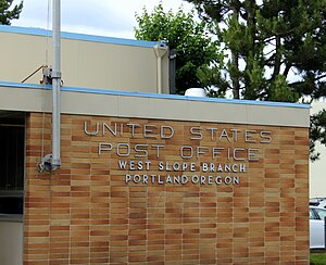
Post office in West Slope
|
|
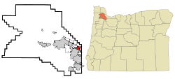
 Location of West Slope, Oregon |
|
| Coordinates: 45°29′50″N 122°46′26″W / 45.49722°N 122.77389°WCoordinates: 45°29′50″N 122°46′26″W / 45.49722°N 122.77389°W | |
| Country | United States |
| State | Oregon |
| County | Washington |
| Area | |
| • Total | 1.7 sq mi (4.5 km2) |
| • Land | 1.7 sq mi (4.5 km2) |
| • Water | 0.0 sq mi (0.0 km2) |
| Elevation | 374 ft (114 m) |
| Population (2010) | |
| • Total | 6,554 |
| • Density | 3,727.1/sq mi (1,439.0/km2) |
| Time zone | Pacific (PST) (UTC-8) |
| • Summer (DST) | PDT (UTC-7) |
| ZIP code | 97225 |
| Area code(s) | 503 |
| FIPS code | 41-80900 |
| GNIS feature ID | 1128896 |
West Slope is an unincorporated suburb of Portland, Oregon, United States and a census-designated place. It is in Washington County, to the west of Portland's West Hills neighborhood, to the northeast of Raleigh Hills and south of U.S. Route 26. Fire protection and EMS services are provided through Tualatin Valley Fire and Rescue.
As of the 2000 census, the suburb population was 6,442. In a plan agreed to by the county and Beaverton, West Slope was scheduled for annexation to Beaverton by 2010.
According to the United States Census Bureau, the neighborhood has a total area of 1.7 square miles (4.4 km2), all land.
As of the census of 2000, there were 6,442 people, 2,873 households, and 1,643 families residing in the neighborhood. The population density was 3,727.1 people per square mile (1,437.7/km²). There were 3,057 housing units at an average density of 1,768.7/sq mi (682.3/km²). The racial makeup of the neighborhood was 88.70% White, 4.30% Asian, 1.44% African American, 0.70% Native American, 0.16% Pacific Islander, 2.22% from other races, and 2.48% from two or more races. Hispanic or Latino of any race were 4.77% of the population.
...
Wikipedia
