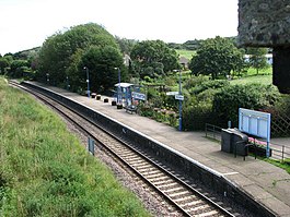
West Runton railway station
| West Runton |
|
|---|---|
 |
|
| Location | |
| Place | West Runton |
| Local authority | North Norfolk |
| Coordinates | 52°56′08″N 1°14′45″E / 52.9355°N 1.2457°ECoordinates: 52°56′08″N 1°14′45″E / 52.9355°N 1.2457°E |
| Grid reference | TG281297 |
| Operations | |
| Station code | WRN |
| Managed by | Abellio Greater Anglia |
| Number of platforms | 1 |
| DfT category | F2 |
| Live arrivals/departures, station information and onward connections from National Rail Enquiries |
|
| Annual rail passenger usage* | |
| 2011/12 |
|
| 2012/13 |
|
| 2013/14 |
|
| 2014/15 |
|
| 2015/16 |
|
| History | |
| Key dates | Opened September 1887 |
| National Rail – UK railway stations | |
| * Annual estimated passenger usage based on sales of tickets in stated financial year(s) which end or originate at West Runton from Office of Rail and Road statistics. Methodology may vary year on year. | |
|
|
|
West Runton railway station is on the Bittern Line in Norfolk, England, serving the village of West Runton. It is 28 miles 55 chains (46.2 km) down the line from Norwich (including the reversal at Cromer, the preceding station on the line). The next station along the line is Sheringham, the northern terminus.
It is one of two remaining Midland and Great Northern Joint Railway stations still in use, Cromer being the other.
The station is managed by Greater Anglia, which also operates all passenger trains that call.
As of December 2016[update], the typical off-peak service at West Runton is one train per hour in each direction between Norwich and Sheringham.
...
Wikipedia
