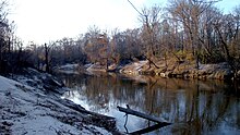
West Pearl River
| Pearl River | |
|---|---|

The Pearl River in Hinds County, MS
|
|
| Country | U.S. |
| Basin features | |
| Main source |
Neshoba County, Mississippi 400 feet (120 m) |
| River mouth | Lake Borgne |
| Basin size | 8,760 square miles (22,700 km2) |
| Physical characteristics | |
| Length | 444 miles (715 km) |
The Pearl River is a river in the U.S. states of Mississippi and Louisiana. It forms in Neshoba County, Mississippi from the confluence of Nanih Waiya and Tallahaga creeks. and has a meander length of 444 miles (715 km). The lower part of the river forms part of the boundary between Mississippi and Louisiana. The river contains large areas of bottomland hardwood swamp and cypress swamp, providing habitat for many species of wildlife including sturgeon and black bears. There was once hope that Ivory-billed woodpeckers might survive here, but this now seems unlikely. The mouth of the river provides important marsh habitat along salinity gradients; these marshes have been the subject of many scientific studies. It is considered to be one of the most critical areas of natural habitat remaining in Louisiana. The Mississippi state capital, Jackson, is located on the river.
The Yockanookany and Strong rivers are tributaries on the upper section and the Bogue Chitto is a tributary on the lower section. The Bogue Chitto's mean low-water discharge is nearly six times the mean low-water discharge of the Pearl River at Jackson, Mississippi, according to a 1936 government report of the Mississippi Planning Commission. Northeast of Jackson, the Ross Barnett Reservoir is formed by a 1962 dam. Average annual rainfall is about 52 inches in the upper third of the basin, and below Jackson the basin rainfall increases to 64 inches or more. The Yockanookany River along with the Lobutcha, Tuscolameta, and Pelahatchie Creeks are major tributaries to the river north of Jackson.
West of Picayune, about 50 miles (80 km) above the mouth, the river forks. The East Pearl River empties into Lake Borgne, where the dredged Pearl River Channel meets the Gulf Intracoastal Waterway. The discharge flows eastward past Grand Island through St. Joe Pass and into the Mississippi Sound. The West Pearl River flows into The Rigolets, thence into Lake Borgne. Both discharges eventually reach the Gulf of Mexico. The Pearl River serves as the 115-mile (185 km) boundary between Mississippi and Louisiana in its lower reach near the Gulf of Mexico.
...
Wikipedia
