West Lampeter Township, Pennsylvania
| West Lampeter Township, Pennsylvania | |
|---|---|
| Township | |

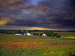
A farm in West Lampeter Township
|
|
 Map of Lancaster County, Pennsylvania highlighting West Lampeter Township |
|
 Map of Lancaster County, Pennsylvania |
|
| Country | United States |
| State | Pennsylvania |
| County | Lancaster |
| Incorporated | 1841 |
| Government | |
| • Type | Board of Supervisors |
| Area | |
| • Total | 16.4 sq mi (42 km2) |
| Population (2010) | |
| • Total | 15,209 |
| • Density | 800.0/sq mi (308.9/km2) |
| Time zone | Eastern (EST) (UTC-5) |
| • Summer (DST) | EDT (UTC-4) |
| Area code(s) | 717 |
| Website | West Lampeter Township |
West Lampeter Township is a township in central Lancaster County, Pennsylvania, United States. The population was 15,209 at the 2010 census.
The Johannes Harnish Farmstead, Christian and Emma Herr Farm, Hans Herr House, Lime Valley Covered Bridge, Neff's Mill Covered Bridge, Park Site, Rock Ford Plantation, and Weber-Weaver Farm are listed on the National Register of Historic Places.
According to the United States Census Bureau, the township has a total area of 16.4 square miles (42.6 km²), all of it land.
As of the census of 2000, there were 13,145 people, 5,284 households, and 3,762 families residing in the township. The population density was 800.0 people per square mile (308.9/km²). There were 5,467 housing units at an average density of 332.7/sq mi (128.5/km²). The racial makeup of the township was 97.35% White, 0.79% African American, 0.05% Native American, 0.60% Asian, 0.01% Pacific Islander, 0.70% from other races, and 0.50% from two or more races. Hispanic or Latino of any race were 1.72% of the population.
...
Wikipedia
