West Garden Grove, California
| West Garden Grove | |||||
|---|---|---|---|---|---|
| Neighborhood of Garden Grove | |||||
|
|||||
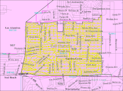
 Location of West Garden Grove neighborhood, map of ZIP Code Tabulation Area 92845, corresponding to West Garden Grove. |
|||||
 Map of Garden Grove, California, with West Garden Grove connected to the rest of the city by a narrow corridor. |
|||||
| Coordinates: 33°47′18″N 118°01′16″W / 33.78833°N 118.02111°WCoordinates: 33°47′18″N 118°01′16″W / 33.78833°N 118.02111°W | |||||
| Population (2010) | |||||
| • Total | 16,333 | ||||
West Garden Grove is a neighborhood in the city of Garden Grove, located in Orange County, California, United States. West Garden Grove encompasses the pene-exclave western portion of the city of Garden Grove. The term West Garden Grove is used on an unofficial basis and is not recognized by the city of Garden Grove. It is bordered to the north by Cypress, to the west by Los Alamitos and Seal Beach, to the south by Westminster, and to the east by Stanton, and connected to the rest of Garden Grove by a narrow strip along Garden Grove Boulevard. It includes the entire 92845 ZIP Code, which is designated as the areas west of Knott Avenue to the Seal Beach and Los Alamitos city borders, and the industrial area east of Knott Avenue to the Stanton border. The community is more affluent than the rest of Garden Grove, with a median income $25,000 greater than the main body of the city. There is also less crime, a lower poverty rate, and the population density is lower compared to the rest of Garden Grove. As of the 2010 Census, 16,333 people reside in West Garden Grove.
As of the census of 2010 for the 92845 ZIP Code, there were 16,333 people, 5,626 households, and 4,395 families residing in the community. The population density was 8,166.5/mi2. There were 5,751 housing units at an average density of 2,875.5/mi2. The racial makeup of the community was 82.3% White, 1.6% Black or African American, 1.2% Native American or Alaskan Native, 13.8% Asian, 1.0% Pacific Islander, 5.2% from other races, and 4.8% from two or more races. 16.2% of the population were Hispanic or Latino of any race.
...
Wikipedia


