West Dulwich
| West Dulwich | |
|---|---|
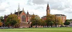
 View of Dulwich College from Alleyn Park |
|
| West Dulwich shown within Greater London | |
| OS grid reference | TQ333722 |
| London borough | |
| Ceremonial county | Greater London |
| Region | |
| Country | England |
| Sovereign state | United Kingdom |
| Post town | LONDON |
| Postcode district | SE21 |
| Dialling code | 020 |
| Police | Metropolitan |
| Fire | London |
| Ambulance | London |
| EU Parliament | London |
| UK Parliament | |
| London Assembly | |
West Dulwich is an area in south London, England, which straddles the London Borough of Lambeth and the London Borough of Southwark. Croxted Road and South Croxted Road mark the boundary between Southwark to the east and Lambeth to the west. The suburb of West Dulwich dates back to the 17th century when the often flooded land known as Dulwich Common was acquired and drained by Edward Alleyn's estate.
West Dulwich has two main parades of shops, the main one being on the Park Hall road junction, where Croxted Road becomes South Croxted Road. Shops there include Tesco, and a number of high end or independent shops. The other parade is on Rosendale Road and has more local-style shops. The Rosendale pub was redeveloped into a gastropub and was awarded the title of TimeOut London Best Gastropub 2007. Another building of note is Beauberry House, which is set in the grounds of Belair Park opposite West Dulwich railway station. The former mansion is now a restaurant.
On the fourth Sunday of every month there is a farmers' market in the grounds of Dulwich College.
At off-peak times West Dulwich railway station is served by four trains per hour into Victoria station. At peak times there are trains to both Victoria and Blackfriars. The closest tube station is Brixton tube station, which is approximately 20 minutes away by bus.
...
Wikipedia

