West Charing
| Charing | |
|---|---|
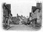
 Charing High Street, c. 1905 |
|
| Charing shown within Kent | |
| Area | 24.9 km2 (9.6 sq mi) |
| Population | 2,766 (Civil Parish 2011) |
| • Density | 111/km2 (290/sq mi) |
| OS grid reference | TQ953494 |
| District | |
| Shire county | |
| Region | |
| Country | England |
| Sovereign state | United Kingdom |
| Post town | Ashford |
| Postcode district | TN27 |
| Dialling code | 01233 |
| Police | Kent |
| Fire | Kent |
| Ambulance | South East Coast |
| EU Parliament | South East England |
| UK Parliament | |
Charing is a mostly agricultural large village and civil parish in the Ashford District of Kent, in south-east England.; it includes the settlements of Charing Heath and Westwell Leacon. It is at the foot of the North Downs and reaches up to the escarpment.
The Pilgrims' Way the M20 motorway and Charing railway station (between London Victoria and Ashford International via Maidstone) serve the parish.
The name Charing first appears in 799 as Ciorrincg. The name probably comes from the Anglo-Saxon word cerring, which means a bend in the road, or it may be from Ceorra-ingas, which is Anglo-Saxon, meaning people of Ceorra. The village is sited on the Pilgrims' Way from London to Canterbury, and is one day's walk from Canterbury. There are a number of old manors located around the village, such as Newlands (now a horse stud) and Pett Place. The village had a market recorded in 1285, and a fair recorded in the fifteenth century.
Church of St Peter and St Paul, the parish church of Charing, is situated next to the remains of the Archbishop's Palace, just off the High Street. The church's west tower was built in the 14th century, though most of the rest of the building was reconstructed following a catastrophic fire in the 16th century. The church contains a number of memorials to the Dering family, a branch of the Dering family of Surrenden Dering, Pluckley, Kent.
Charing has had four mills over the centuries, serving the needs of the villagers. There were two watermills on the Upper Great Stour and two windmills.
...
Wikipedia

