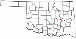
Weleetka, Oklahoma
| Weleetka, Oklahoma | |
|---|---|
| Town | |
 Location of Weleetka, Oklahoma |
|
| Coordinates: 35°20′44″N 96°8′5″W / 35.34556°N 96.13472°WCoordinates: 35°20′44″N 96°8′5″W / 35.34556°N 96.13472°W | |
| Country | United States |
| State | Oklahoma |
| County | Okfuskee |
| Area | |
| • Total | 0.7 sq mi (1.8 km2) |
| • Land | 0.7 sq mi (1.8 km2) |
| • Water | 0.0 sq mi (0.0 km2) |
| Elevation | 725 ft (221 m) |
| Population (2010) | |
| • Total | 998 |
| • Density | 1,425.7/sq mi (554.4/km2) |
| Time zone | Central (CST) (UTC-6) |
| • Summer (DST) | CDT (UTC-5) |
| ZIP code | 74880 |
| Area code(s) | 405 |
| FIPS code | 40-79800 |
| GNIS feature ID | 1099475 |
Weleetka is a town in Okfuskee County, Oklahoma, United States. It is about 10 miles (16 km) southeast of Okemah, the county seat. The name is a Creek word meaning "running water." The population was 998 at the 2010 census, a decline of 1.6 percent from 1,014 at the 2000 census.
Weleetka is located at 35°20′44″N 96°8′5″W / 35.34556°N 96.13472°W (35.345626, -96.134592). It is 10 miles (16 km) seutheast of the county seat, Okemah. The townsite is on a horseshoe bend of the North Canadian River.
According to the United States Census Bureau, the town has a total area of 0.7 square miles (1.8 km2), all land.
As of the census of 2000, there were 1,014 people, 368 households, and 235 families residing in the town. The population density was 1,463.7 people per square mile (567.4/km²). There were 450 housing units at an average density of 649.6 per square mile (251.8/km²). The racial makeup of the town was 60.36% White, 6.31% African American, 23.77% Native American, 0.10% Asian, 1.08% from other races, and 8.38% from two or more races. Hispanic or Latino of any race were 2.66% of the population.
...
Wikipedia
