Wauchula, FL
| Wauchula, Florida | ||
|---|---|---|
| City | ||
| City of Wauchula | ||

Wauchula Chamber of Commerce in 2010
|
||
|
||
| Motto: "Building New Beginnings From Old Traditions" | ||
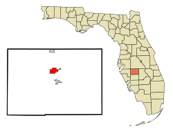
 Location in Hardee County and the state of Florida |
||
| Coordinates: 27°32′46″N 81°48′52″W / 27.54611°N 81.81444°WCoordinates: 27°32′46″N 81°48′52″W / 27.54611°N 81.81444°W | ||
| Country |
|
|
| State |
|
|
| County | Hardee | |
| Incorporated | September 29, 1902 | |
| Area | ||
| • Total | 2.6 sq mi (6.8 km2) | |
| • Land | 2.6 sq mi (6.8 km2) | |
| • Water | 0 sq mi (0 km2) | |
| Elevation | 112 ft (34 m) | |
| Population (2000) | ||
| • Total | 4,368 | |
| • Density | 1,680/sq mi (642.4/km2) | |
| Time zone | Eastern (EST) (UTC-5) | |
| • Summer (DST) | EDT (UTC-4) | |
| ZIP code | 33873 | |
| Area code(s) | 863 | |
| FIPS code | 12-75375 | |
| GNIS feature ID | 0292949 | |
| Website | cityofwauchula |
|
Wauchula is a city located in Hardee County, Florida, United States, and had a population of 4,368 at the 2000 census. According to the U.S. Census Bureau's 2004 estimates, the city had a population of 4,441. It is the county seat of Hardee County.
Wauchula has been called the "Cucumber Capital of the World", although citrus has become a more important agricultural crop over the past few decades.
Wauchula is located at 27°32′46″N 81°48′52″W / 27.54611°N 81.81444°W (27.546091, -81.814564).
According to the United States Census Bureau, the city has a total area of 2.6 square miles (6.7 km2).
As of the census of 2000, there were 4,368 people, 1,431 households, and 985 families residing in the city. The population density was 1,669.6 people per square mile (643.7/km²). There were 1,562 housing units at an average density of 597.0 per square mile (230.2/km²). The racial makeup of the city was 73.44% White, 4.17% African American, 0.57% Native American, 0.30% Asian, 18.84% from other races, and 2.68% from two or more races. Hispanic or Latino of any race were 39.42% of the population.
...
Wikipedia

