Watertown Square
|
WATERTOWN SQUARE
|
|
|---|---|

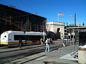
A #71 trolleybus boarding passengers at the start of an inbound trip
|
|
| Location | Watertown Square, Watertown, Massachusetts |
| Coordinates | 42°21′56″N 71°11′08″W / 42.36546°N 71.18564°WCoordinates: 42°21′56″N 71°11′08″W / 42.36546°N 71.18564°W |
| Owned by | Massachusetts Bay Transportation Authority |
| Line(s) |
|
| Construction | |
| Disabled access | Yes |
Watertown Square is the main square of Watertown, Massachusetts, located at the confluence of North Beacon Street and Main Street (US-20), Mt. Auburn Street (MA-16), Pleasant Street, Arsenal Street, and Charles River Road. The Armenian Library and Museum of America is located in the square; Watertown Dam is 1,000 feet (300 m) to the west.
Watertown Square is a minor transfer point for MBTA Bus services. Two routes terminate at a two-lane bus loop that forms the west side of the square; the 71 is one of four trolleybus routes operated from the Harvard Bus Tunnel and a key bus route.
Two additional routes pass on the north side of the square on US-20; they serve a westbound stop just north of Watertown Square, and an eastbound stop a block to the west.
Watertown Yard, located 300 feet (91 m) to the south across the Watertown Bridge, is also a bus transfer point. Trolleybus wires for the 71 run to Watertown Yard, which at times has been used as a depot for the trolleybuses. From June through December 1984, the 71 and 70 short turns were extended to Watertown Yard during reconstruction at the square.
...
Wikipedia
