Warren, Idaho
|
Warren, Idaho a.k.a. Warren's Camp, Warren's, Warrens |
|
|---|---|
| Unincorporated settlement | |

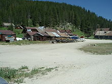
Downtown Warren, July 2008
|
|
| Coordinates: 45°15′50″N 115°40′37″W / 45.264°N 115.677°WCoordinates: 45°15′50″N 115°40′37″W / 45.264°N 115.677°W | |
| Country | United States |
| State | Idaho |
| County | Idaho |
| Elevation | 5,906 ft (1,800 m) |
| Population (2010) | |
| • Total | 16 |
| Time zone | Mountain (MST) (UTC-7) |
| • Summer (DST) | MDT (UTC-6) |
| ZIP code | 83671 |
| Area code(s) | 208 |
Warren is an unincorporated community in the remote north central region of the U.S. state of Idaho, near the Frank Church River of No Return Wilderness.
Located within the Payette National Forest in southern Idaho County, Warren is northeast of McCall, approximately 50 miles (80 km) by vehicle and about 30 miles (50 km) by air. South of the Salmon River, the elevation is 5,906 feet (1,800 m) above sea level.
According to the Köppen climate classification system, Warren has a subarctic climate (Köppen Dfc).
Miners from the previous gold strikes in Pierce and Florence fanned out to the south and discovered gold in the Warren Creek area in August 1862. It led to the formation of the settlement, then in Washington Territory, making it one of the oldest settlements in present-day Idaho. With a gold mining boom in multiple regions during the Civil War, the Idaho Territory was established in 1863. Shortly after the gold discovery by Lewiston's James Warren, the Warren's Camp population swelled to over 2,000; the southerners called their area of the camp "Richmond" and northerners called theirs "Washington."Washington was established as the seat of Idaho County from June 1, 1869 until voters in the June 1875 election selected Mount Idaho over Slate Creek and Washington.
...
Wikipedia
