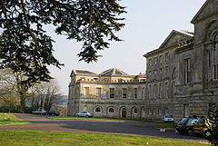
Wardour, Wiltshire
Wardour /ˈwɔːrdər/ is a settlement in Wiltshire, England, about 13 miles (21 km) west of Salisbury and 4 miles (6 km) south of Hindon. Formerly a parish in its own right, it is now part of the civil parish of Tisbury.
The land was an estate of Wilton Abbey by the 11th century.
The old 15th century Wardour Castle was slighted during the English Civil War, The stronghold was replaced in 1776 by New Wardour Castle, built between 1769 and 1776. It was long the home of the Lords Arundell of Wardour and later of Cranborne Chase School.
All Saints' Roman Catholic chapel, Wardour, originally belonged to the Arundells' household. It was enlarged in 1788 by the eighth Lord Arundell to the designs of Giacomo Quarenghi and John Soane. The chapel still has regular services and is also used for musical events.
In the 18th century part of the estate was in Tisbury parish and part in Donhead St Andrew. In 1835 Tisbury was divided into three parishes: East Tisbury, West Tisbury and Wardour. In 1927 East Tisbury and Wardour were united as Tisbury civil parish.
Wardour Catholic Primary School was built in 1862.
John Marius Wilson's Imperial Gazetteer of England and Wales (1870-1872) said of Wardour:
...
Wikipedia


